Catalog Archive
Auction 137, Lot 840

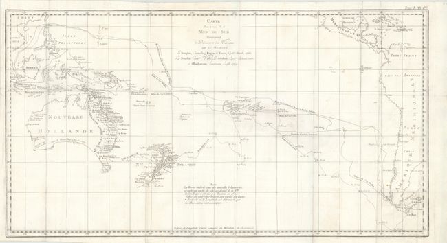
"Carte d'une Partie de la Mer du Sud Contenant les Decouvertes de Vaisseaux de sa Majeste le Dauphin, Commodore Byron, la Tamar, Capitne. Mouats, 1765, le Dauphin, Capitne. Wallis, le Swallow, Capitne. Cartaret, 1767, et l'Endeavour, Lieutenant Cook 1769", Cook/Benard

Subject: South Pacific Ocean & Australia

Period: 1774 (circa)

Publication: Voyages dans l'Hemisphere Australe

Color: Black & White

Size:
26 x 14 inches
66 x 35.6 cm
Download High Resolution Image
(or just click on image to launch the Zoom viewer)

Captain James Cook is believed to be the greatest navigator of his day, and contributed to the mapping of Australia and the Pacific more than any other explorer. During his first voyage of 1768-71 on the Endeavour, he charted New Zealand and the eastern coast of Australia. This map follows the voyages of Cook and other explorers of the South Pacific Ocean between 1765 - 1769. The routes of Byron, Mouats, Wallis, Carteret, and Cook are depicted, with indications of the dates of their travels and their discoveries. A notation on the map indicates that the shaded coastlines are the new discoveries of these explorers. The southeastern tip of Australia is still connected to Tasmania, and the inland area is blank as it was still unexplored at the time.

References: Tooley (Australia), #334.

Condition: B+

Folding, as issued. Light soiling with a few short tears in blank margins that do not enter map image. Also a few minor paper flaws that do not affect map image.

Estimate: $450 - $600

Sold for: $325

Closed on 9/14/2011

Archived