Subject: France - Departments
Period: 1869 (published)
Publication: Atlas National Illustre
Color: Hand Color
Size:
11 x 17 inches
27.9 x 43.2 cm
Victor Levasseur's "Atlas National Illustre" and "Atlas Universel Illustre" are among the last decorative atlases published. The maps are all lavishly illustrated with scenes of the countryside, products and activities indigenous to the region.
This lot includes 9 maps of French departments from Levasseur's Atlas National Illustre:
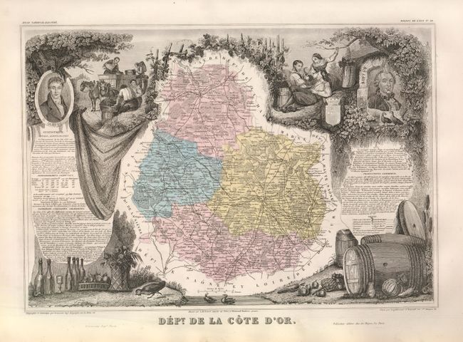
A. Dept. de la Cote d'Or. The Côte d’Or is the heartland of Burgundy, where the region’s most famous and expensive wines are found. The Côte d'Or itself is split into two parts: the Côte de Nuits situated south of Dijon and the Côte de Beaune in the vicinity of the town of Beaune. The Côte de Nuits is most famous for its red wines produced from Pinot Noir grapes. The Côte de Beaune is renowned for its white wines derived from the Chardonnay grape. Small amounts of rose and sparkling wine are also produced. Burgundy is home to some of the most expensive wines in the world, including those of Domaine de la Romanee-Conti, Domaine Leroy, Henri Jayer, Emmanuel Rouget, Domaine Leflaive and Domaine Armand Rousseau. This is Levasseur's most evocative wine region map with scenes of the harvest and grapevines across the top and wine barrels and bottles at bottom.
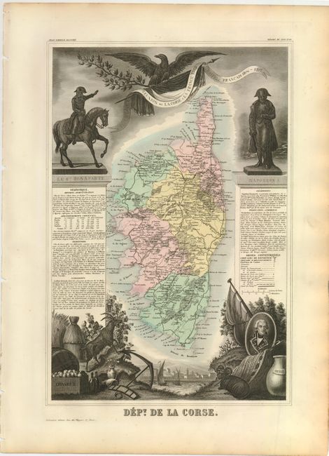
B. Dept. de la Corse. Levasseur's map of Corsica highlights the history of the island, with vignettes of two statues of Napoleon Bonaparte, who was born in the town of Ajaccio on the island. French text on either side of the map describes the political divisions, topography, important sites, and commerce of Corsica. The bounty of the island is also shown in vignettes at bottom, with oranges, wine and olive oil featured along with a portrait of Pascal Paoli, another native who became an elected leader, and eventually led the Corsican resistance against the French during the conquest of Corsica in 1768.
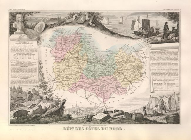
C. Dept. des Cotes du Nord. This map depicts Cotes-d'Armor, one of five departments in the province of Brittany in the northwest of France. French text on either side of the map describes the political divisions, topography, important sites, and commerce of the region. Vignettes surrounding the map include a stone portrait of Bertrand-François Mahé de La Bourdonnais, a French naval officer; a view of St.-Brieuc, the capital of the region; the robust fishing industry; native animals, and various products of the region.
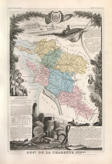
D. Dept. de la Charente Infre. This map depicts Charente-Maritime, one of four departments in the province of Poitou-Charentes in the west of France. French text on either side of the map describes the political divisions, topography, important sites, and commerce of the region. Vignettes surrounding the map feature La Rochelle, the capital of Charente-Maritime, including stone portraits of two natives of La Rochelle, Admiral Guy-Victor Duperré and scientist René Antoine Ferchault de Réaumur, a view of the city, and the coat of arms of the city. Below the map is a vignette of the produce of the region.
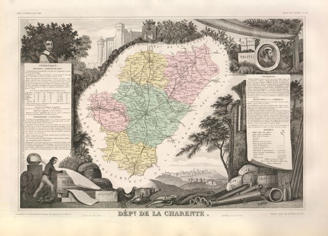
E. Dept. de la Charente. A large part of the Charente department falls within the region of Cognac, home of the world’s most famous brandy. The cities of Jarnac, Segonzac and Cognac form the center of the region. The vineyards along the banks of the Charente River produce the Ugni Blanc, Folle Blanche and Colombard grapes that make up the wine from which cognac is distilled. Only six regions, or crus, are allowed to produce wines for cognac: Grande Champagne, Petite Champagne, Borderies, Fins Bois, Bons Bois, and Bois Ordinaires. Each cognac house has a unique process to mix its eaux-de-vie (waters of life), a barrel of which is pictured at bottom right.
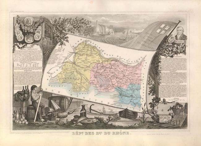
F. Dept. des Bes. du Rhone. This map depicts Bouches-du-Rhone, named after the mouth of the Rhone River and a department in Provence in the south of France. French text on either side of the map describes the political divisions, topography, important sites, and commerce of the region. Vignettes surrounding the map feature Marseille, the capital of the department and one of the main gateways to France, including portraits of famous natives of the region, a view of the city, and the coat of arms of the city. Below the map is a vignette of the produce of the region, highlighting the fishing industry and production of olive oil.
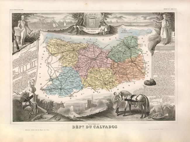
G. Dept. du Calvados. This map shows the French department of Calvados, part of the region of Basse-Normandie in Normandy. It takes its name from a cluster of rocks off the English Channel coast that are graphically depicted on the map. It is also the location of Juno Beach, one of the location for the famous D-Day invasion of WWII. Includes the cities of Bayeux and Caen, and much of Normandy. Surrounded by beautifully engraved views representing the people and commerce of the area.
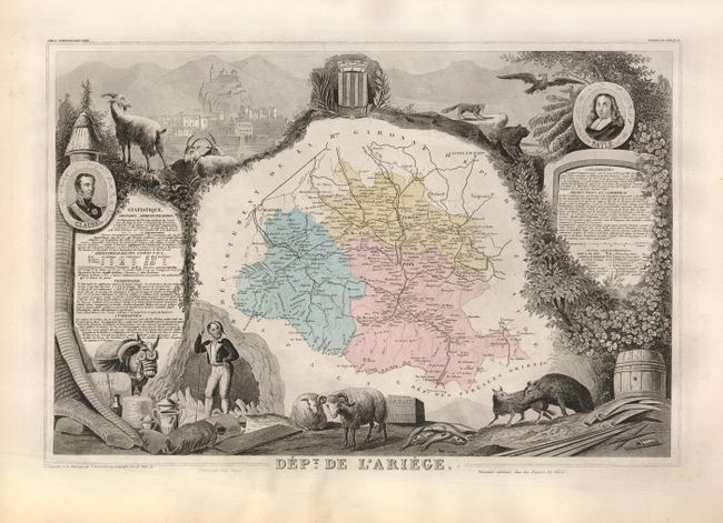
H. Dept. de l'Ariege. Located in southwestern France, Ariege is named after the Ariege River, which runs through it. The castle at Foix, the capital of the department, is depicted at top left. Portraits of Bertrand Clausel, a Marshal of France, and Pierre Bayle, philosopher and author of Dictionnaire historique et critique, flank the map. Below the map are depictions of the various industries in Ariege, including butter, wool, paper, and iron mining.
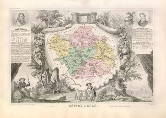
I. Dept. de l'Aube. The Aube is the southernmost of the Champagne wine regions. Though overshadowed by the famous names of Rheims and Epernay to the north, this region of Aube en Champagne is - the locals claim - bubbly's true home. It was here that Saint Bernard of Clairvaux first planted the chardonnay and pinot vines more than 700 years ago that are at the heart of the world's greatest vines. Almost half of the Aube harvest goes into the bottles bearing the famous labels of Mumm, Piper-Heidsieck and Laurent- Perrier. The vineyards of the Côte des Bar south of the town of Troyes form a peak, with Bar-sur-Aube at the top and a line along Bar-sur-Seine and les Riceys at the bottom. At bottom left a hunter celebrates his success with a bottle.
Size varies slightly.
References:
Condition: A
Original color, as issued, with minor surface soil and toning in the margins. Binding holes in far blank margins.