Subject: Eastern United States
Period: 1849 (dated)
Publication:
Color: Hand Color
Size:
25 x 20 inches
63.5 x 50.8 cm
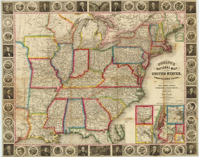
A nice example of the third edition of this folding pocket map. The map extends to the Great Plains and includes part of Texas with two large unnamed regions extending northward, presumably the Indian territories and Iowa Territory. The map is filled with details including roads, towns and villages, railroads, rivers and much more. Delineates the Trader’s Route to Santa Fe in Missouri and through the territory to the west. Names numerous Indian tribes, Burial Grounds, and trading depots. It is embellished with a surrounding border featuring finely engraved portraits of 16 famous Americans, the seals of 30 states including Texas (but not California), the signing of the Declaration of Independence, and the seal of the United States. This early edition does not have the large inset "Map of Oregon, California & Texas" that appears soon after this issue at lower right. Here the original insets include the vicinity around Baltimore, Philadelphia, Boston, New York, Pittsburgh, Cincinnati, Chicago, and St. Louis. The southern tip of Florida and the north part of Maine are shown in insets as well.
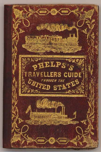
The map is attached to the rear cover of Phelps’s Travellers’ Guide through the United States; containing Upwards of Seven Hundred Rail-road, Canal, and Stage and Steam-Boat Routes, accompanied with a New Map of the United States. The 70 page booklet contains all manner of information valuable to the traveler including distance tables for stage, canal, steamboat and railroads listed by state and an extensive index of place names . Hardbound in reddish-brown leather (3.5 x 5.5") with an elaborate cover design embossed in gilt showing an early train and the steamship St. Louis. Gilt on fore edges (T.E.G.).
References:
Condition: B+
This is a nice example with a few scattered stains and some light toning. The verso is backed with Japanese tissue to reinforce and repair a few fold splits and separations, one of which has since partially reopened (lower right inset near Long Island). The map was issued folded and is separated from the covers.