Subject: South America
Period: 1794 (dated)
Publication:
Color: Hand Color
Size:
46.5 x 20.5 inches
118.1 x 52.1 cm
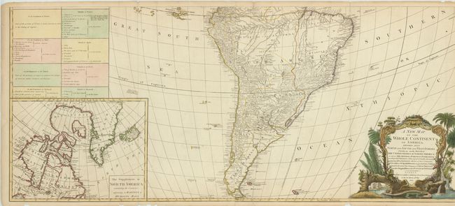
These are the southern two sheets (joined) of a four sheet set of the Americas. It was originally drawn by John Gibson in 1763 with a slightly different title. The map went through several revisions; this is the sixth and final state. The map is filled with incredible detail and is based on D'Anville's cartography. This section shows the political boundaries, cities, mountains and watershed of South America. Terra del Fuego is prominently shown at the bottom of the image while the inland area around the Amazon is left largely blank. At lower left is an inset map of Hudson and Baffin's Bay in North America. Above the inset is a large text panel with a partial listing of the Articles of the Treaty of Paris of 1763. The baroque-style title cartouche features a beaver, a crocodile and an Indian headdress amid trees, a waterfall and tropical flora.
References: Tooley (Amer) p. 51, #3f; Stevens & Tree #3f.
Condition: B
There are some tears along the bottom border entering the image and some chips out of the blank margin. Faint toning.