Subject: St. Kitts, Lesser Antilles
Period: 1720-1767 (circa)
Publication:
Color:
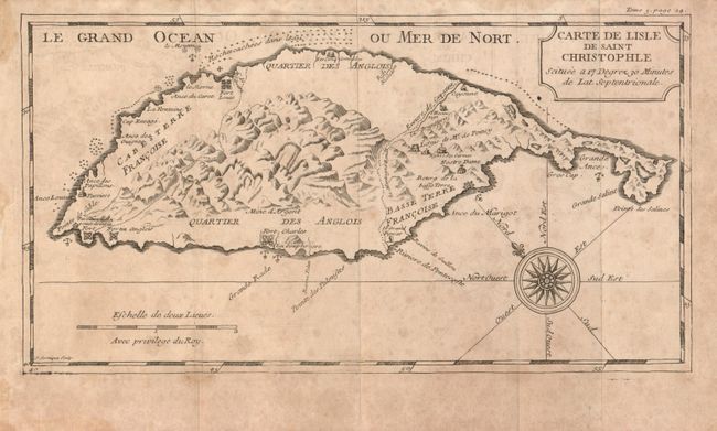
Carte de l'Isle de Saint Christophe Situee a 17 Degrez 30 Minutes de Lat. Septentrionale, by J.B. Labat, from Nouveau Voyage aux Isles de l'Amerique, circa 1722, black & white, (5.2 x 9.6"). Based on Sanson's map from 1650, this map divides St. Kitts into three parts, with the center marked as English and the eastern and western parts marked as French. The mountainous topography of St. Kitts is depicted along with forts, churches, and hidden rocks in the coastal waters. The map also features a compass rose. Ref: Tooley (MCC-81), #16-17. Condition: Some toning and foxing. Issued folding with minor offsetting. (B)
br>
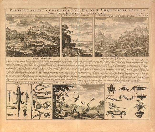
Particularitez Curieuses de l'Ile de St. Christophle et de la Province de Bemarin dans les Antilles, by Chatelain, from Atlas Historique…, circa 1720, black & white, (18.8 x 14.5"). This sheet presents several views of St. Kitts and the native fauna. The view at upper left shows the Governor-General's palace - complete with elaborate formal French gardens. The view at center shows the natives welcoming the French and preparing a feast. The view at right depicts Melilot, the mythical capital of Apalache. This idealized view was taken from Charles de Rochefort's view first published in his Histoire naturelle et morale des iles Antilles de l'Amerique [1658]. The Apalache were purported to have a utopian kingdom in Georgia and Florida, and to have been the ancestors of the Carib peoples. As Melilot was not found in North America, here it has been transferred to St. Kitts. The views at bottom show a variety of native reptiles, fish, birds, and insects. Ref: Tooley (MCC-81), #13. Condition: Dark impression with overall toning and minor foxing. (B+)
br>
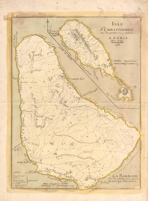
Isle St. Christophle und des antilles aux anglois... La Barbade une des antilles aux Anglois divisee par Paroisses, by Crepy, dated 1767, hand color,
(8 x 10.8"). This sheet contains a detailed map of Barbados and a smaller inset of St. Kitts, each drawn on a different scale. A legend in the corner of the map identifies towns, churches, forts and plantations of various sizes. The map also indicates rocks in the waters around the coastlines. Ref: Tooley (MCC-81), #27. Condition: Stains at top and a small hole to the southeast of St. Kitts. (B)
References:
Condition:
See description.