Subject: Long Island, New York
Period: 1870 (circa)
Publication:
Color: Black & White
Size:
14.3 x 9.3 inches
36.3 x 23.6 cm
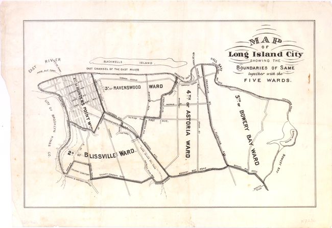
Long Island City is today included in present-day Queens across the East River from Manhattan. Shows the five wards: 1st or Hunter's Point, 2d or Blissville Ward, 3d or Ravenswood Ward, 4th or Astoria Ward, and 5th or Bowery Bay Ward. The city boundary shows it separated from Brooklyn by Newtown Creek, with the boundary continuing to Hell Gate, Lawrence Point and Bowery Bay, along Bowery Bay Road and Calvary Cemetery Road. Blackwells Island and the James Slip and 34th Street ferries are located. Printed on thin banknote-quality paper.
During the early 1800s wealthy New Yorkers built mansions in the Astoria area to escape the city crowds. Stephen Halsey developed the area as a village, and named it Astoria, in honor of John Jacob Astor. In 1870 Long Island City was chartered from the consolidation of Astoria, Ravenswood, Hunters Point and Steinway. In 1898, Long Island City officially became part of New York City when it expanded its borders to include what is now Queens. An uncommon map.
References:
Condition: B+
Sound example with just a few light creases and a small stain at right neatline. Full margins with binding trim as issued.