Subject: Colonial Mid-Atlantic
Period: 1777 (dated)
Publication:
Color: Hand Color
Size:
22.1 x 29.5 inches
56.1 x 74.9 cm
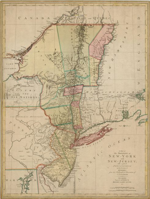
A beautiful Revolutionary War period map of New York and New Jersey with portions of Pennsylvania and Quebec. The map details areas crucial to the war's early years, particularly the Hudson Valley and Lake Champlain. It covers from the eastern edge of Lake Ontario up the St. Lawrence to the Connecticut River in the north, and from Chesapeake Bay along the New Jersey shore to Long Island across to Martha's Vineyard in the southern portion of the map. The western part of New York is labeled Country of the Six Nations referring to the Indian nations of the Iroquois Confederacy. One of the nicer features of this large map is the meticulously rendered river systems and towns, particularly the Hudson and Connecticut Rivers. Large counties fill the northern part of New York and a line bisects New Jersey into eastern and western provinces. The prime meridian is shown through New York. There is a small inset map of Chesapeake Bay at lower left. This map is a smaller version, re-engraved by Lotter, of Claude Joseph Sauthier's map of 1776 that was published in London by Faden. This issue by Lotter was directed at a German audience, probably because of the high number of German mercenaries fighting with the British army and the increasing international interest by Europeans in North American affairs. This example was obviously issued for military use; printed on two joined sheets and backed with contemporary linen.
Claude Joseph Sauthier, a French draughtsman and surveyor, drew on his own detailed surveys for this map, as well as on the surveys of Bernard Ratzer another important surveyor and mapmaker in the years preceding the Revolution. Sauthier accompanied William Tryon to North Carolina in 1767 and then to New York in 1771. Appointed surveyor for the Province of New York in 1773 he was involved in determining the disputed boundaries of the province. After 1776 he was employed as a military surveyor. His map gave British commanders an excellent overview of areas that would be crucial in the early years of the war,
edition. The prime meridian is New York. An inset of the Chesapeake Bay is at the lower left.
References: McCorkle #777.20; Sellers & Van Ee #1048.
Condition: A
Original color with light overall toning and some minor surface soil.