Subject: Continents
Period: 1732 (circa)
Publication:
Color: Hand Color
Size:
27.5 x 19.3 inches
69.9 x 49 cm
A matched set of some of the most distinctive and decorative maps of the 18th century. It is the border decorations that make these map stand out; each is intricately engraved with ornamental elements. The maps were drawn and engraved by J. Luillier and published by Guillaume Danet, son-in-law of Nicholas de Fer. Danet was not a prolific publisher and these separately issued maps are quite scarce, especially in a matched set. Size varies slightly.
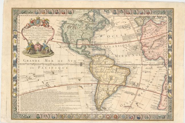
1. L'Amerique Meridionale et Septentrionale Dressee sur les Nouw les Decoutes et dernieres Relations des meilleurs… Cartographically based on Delisle's map of the Americas, it represents the standard view of the New World during this period. Portraits of the New World explorers run along the top and bottom and on either side are illustrations of the signs of the zodiac. A large inset panel of text provides historical notes on the explorers portrayed in the panels. Numerous other notes across the map provide a fascinating complement to the geography on the map itself.
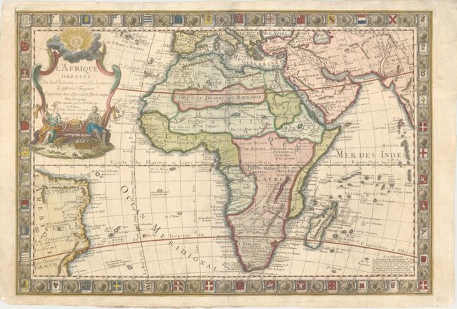
2. L'Afrique Dressee sur les Relations & Nouvelles Decouvertes de Differens Voyageurs Conformes aux Observations Astronomiques Based on Delisle's updated map of Africa [1722], this map shows separate Senegal and Niger rivers and the large Lac de Maravi (Nyasa) and the Lepala mountain range noted as the spine of the world. The decorative border is composed of the flags of nations throughout the world.
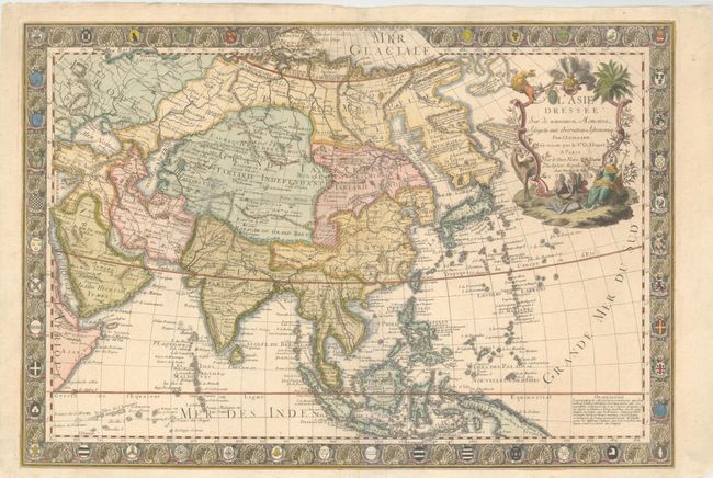
3. L'Asie Dressee sur de Nouveaux Memoires Assujetis aux Observations Astronomiq. While much of the map is based on Delisle's revised map of Asia [1722], this map presents an early depiction of Kamchatka taken Strahlenberg's map [1730], which was in turn based on the work of Abu Al-Ghazi Bahadur's history of the Tartars. There are a number of notations in the region noting that the inhabitants either pay tribute to, or are the enemies of, the Moscovites. Korea is depicted as a blunt peninsula and the sea between it and Japan is called the Detroit de Coree. The border is composed of the coats of arms of Asian nations.
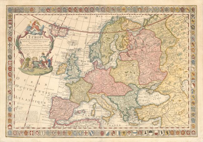
4. L'Europe Divisee dans ses Principaux Etats Subdivises en leurs Principales Provinces. Fellow French cartographer, Louis Charles Desnos, is credited for this map of Europe. Coats of arms of the European nations form the elaborate border.
References:
Condition: B+
There is some light soil and old creases with mostly minor professional repairs. There is a tear from the centerfold to the bottom left that is neatly repaired.