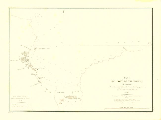
Subject: Valparaiso, Chile
Period: 1823 (dated)
Publication: Voyage autour du monde, Execute par Ordre du Roi…
Color: Black & White
Size:
19.5 x 14.2 inches
49.5 x 36.1 cm
Very detailed chart of the bay, surrounding village and the fortified Chateau Sn. Rosario. Shows excellent detail including individual buildings, anchorages, soundings and more. This chart apparently combines the explorations of Alessandro Malaspina and Duperrey. Malaspina (1754 - 1810) was a nobleman of Italian birth who spent most of his life as a Spanish naval officer and explorer. Under a Spanish royal commission, he undertook two scientifically based voyages around the world in 1786 - 1788 and 1789 - 1794. His explorations included the Pacific Ocean, much of the west coast of the Americas all the way north to the Gulf of Alaska, across the Pacific to Guam and the Philippines, onward to New Zealand, Australia, and Tonga.
Duperrey concentrated his explorations primarily in the Pacific. But his ship Coquille "called at Brazil, the Falkland islands, Concepcion, Callao, and Payta. The Pacific islands visited were the Tuamotu Archipelago, Tahiti and the Society Islands, Tonga, Rotuma, the Gilbert and Caroline Islands, and the Bismarck Archipelago" (Hill 517). His atlas Voyage auctour du Monde was never completely published, but various partial editions were issued by different printers and publishers over many years in the first half of the 19th century.
References:
Condition: A
A few very light, diffuse spots in map, still very good on bright, clean paper with original margins and crisp impression.