Subject: Texas, Railroads
Period: 1909 (published)
Publication:
Color: Printed Color
Size:
22.3 x 20.5 inches
56.6 x 52.1 cm
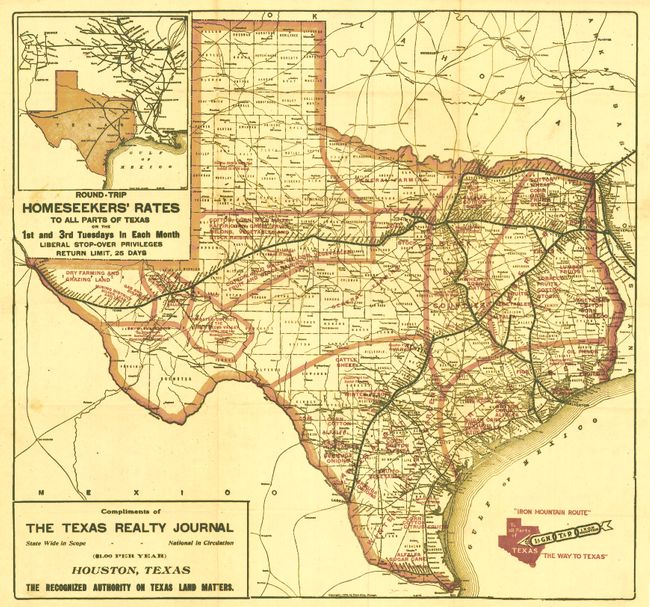
This great folding advertising map was published to encourage settlement of the state and to promote the various rail routes including the International & Great Northern, Texas & Pacific, and Iron Mountain railroads. The rail lines are boldly shown in black with all stations noted and named. Red overprinting is used to locate farming and ranching opportunities for settlers including lands that support corn, cotton, citrus fruits, alfalfa, Bermuda onions, cattle, sheep, etc. The area around Amarillo is devoid of any such 'opportunities' for the land seeker, unfortunately large gas and oil fields were discovered a few years after this map's publication. Large inset at upper right shows external rail connections, with the title "Round-Trip Homeseekers' Rates to All Parts of Texas on the 1st and 3rd Tuesdays in Each Month." At lower left the inset is "Compliments of the Texas Realty Journal…Houston, Texas, the Recognized Authority on Texas Land Matters." A scarce issue that is printed on thin banknote-style paper. Folding and contained in the original mailing envelope of the Texas Realty Journal including a 2 page typed letter from the editor and a return envelope. The envelope and letter are addressed to Mr. John F. Jansen in Peoria, Ill. The mailing envelope is dated Dec. 31, 1912 and still carries the 1¢ stamp.
References:
Condition: A
The map is near fine with just a small light stain in blank area at edge and a couple of small fold intersection splits.