Subject: World
Period: 1795 (dated)
Publication:
Color: Black & White
Size:
29.5 x 18.5 inches
74.9 x 47 cm
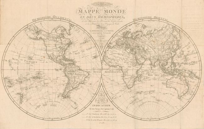
Captain Cook's three voyages are chronicled on this scarce, large-scale chart. Precisely engraved and filled with finely rendered detail in the interior and along coastlines. The map includes the latest information from the discoveries of Cook. The legend gives the dates and delineates the route of the three different voyages. In the Pacific, New Zealand is shown with both its French title and the original Maori names for each island. In Africa the interior is left largely blank, but the Nile is still shown originating from two lakes above the Mountains of the Moon. The arctic passage of Cluny in 1768 is delineated. Cook's observations in Antarctica are detailed including large ice floes. This map is dated 1795 making it an earlier edition than we find in any library or past sales records.
References:
Condition: B+
Folded as issued. Very nice impression with no flaws, save a printer's crease in upper middle, just one small spot near Hawaii and a light stain in blank margin to right. Some archival tape on verso to support fold lines. On a very large single sheet of hand laid paper with large watermark.