Subject: Minnesota
Period: 1855 (dated)
Publication:
Color: Hand Color
Size:
22 x 30 inches
55.9 x 76.2 cm
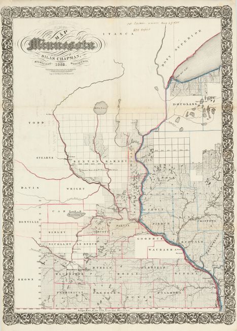
This is the first edition of this important Minnesota map. The map actually covers only the eastern part of Minnesota Territory with the adjacent part of Wisconsin along the Mississippi and St. Croix rivers. The counties west and north of St. Paul are shown in their early, larger incarnations, and the region along the north shore of Lake Superior is unsurveyed. A brown ink, manuscript notation at top notes "1st edition received Aug. 27, 1855 - 500 copies." Further notations on the verso appear to be publisher's notations and indicate this may be a proof copy. The folds also indicate it was never bound into a pocket case.
Silas Chapman was an important Midwestern map publisher during the period of rapid expansion in the region (1850-1875). When he first arrived in Wisconsin he was an educator, co-editor of the Milwaukee Sentinel, and publisher of the Milwaukee Herald. He then turned his interests to book-selling, stationery, bookbinding and printing, at first in partnership with Philetus C. Hale and after 1850 alone. He was best known as a publisher of county, city, railroad, and geological maps focusing specifically on the states of Wisconsin, Minnesota, Iowa, and Illinois. Upon his retirement the Chapman firm was acquired by Dyer and Pasmore, who continued to update and republish his maps into the 1880s.
References:
Condition: B+
Issued folded with minor repairs at fold intersections, with one affecting a few letters than have been replaced in skilled facsimile. Manuscript notation at top.