Subject: California, Gold
Period: 1848 (published)
Publication: 30 Cong., 2nd Sess., HR Ex. Doc. No. 1
Color: Black & White
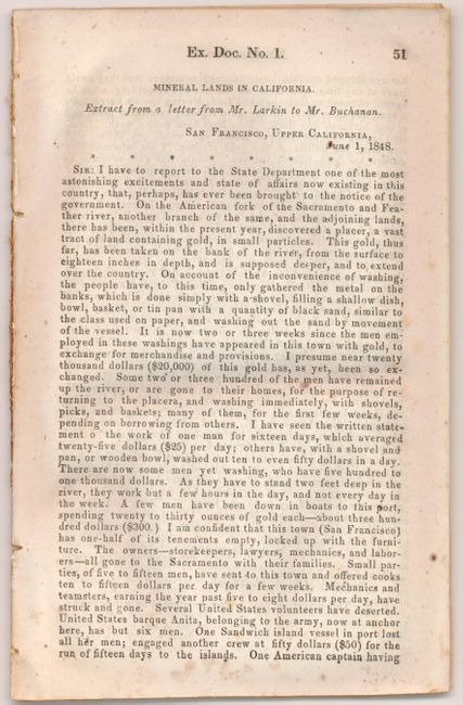
This important early government correspondence written by Thomas O. Larkin to Mr. James Buchanan, then Secretary of State under President Polk, contains the report written by R. B. Mason to Larkin in San Francisco. Gold was first discovered in January, 1848 and Sutter tried in vain to keep the discovery quiet. In July, Col. Mason, the Military Governor of California in Monterrey, toured the diggings and sent a report to Buchanan officially announcing the discovery of gold. These maps and this report are largely responsible for spawning the great California Gold Rush. The 20pp [51-70] disbound report is complete with the three important folding maps which are the earliest printed maps to actually name and locate gold discoveries in California. The first two maps were drawn by Lt. William T. Sherman, of later Civil War fame, when he was adjutant to U.S. Military Gov. Mason.
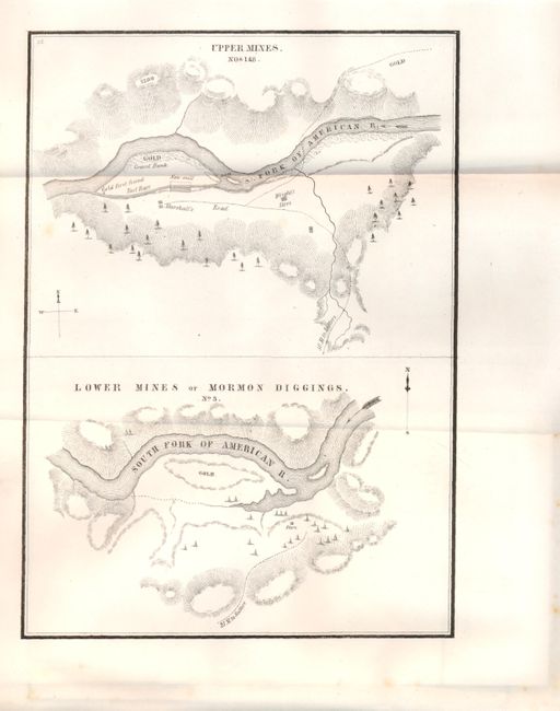
1) Upper Mines / Lower Mines or Mormon Diggings. (6.3 x 8.8") second map (6.4 x 9") contains two maps within one border. The Upper Mines are along the South Fork of the American River and notes where gold first found by James W. Marshall. The lower map "Lower Mines of Mormon Diggings" depicts numerous tents surrounding a store with a large area of the river bar marked gold. Dark impression and full margins. Two tiny spots in lower wide margin, still fine. (A+)
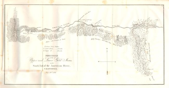
2) Positions of the Upper and Lower Gold Mines on the South Fork of the American River, California. (18.4 x 9.3") The map actually names and locates the gold discoveries, and one of the best first-hand accounts of the Gold Rush. It covers the country along the American River from its junction with the Sacramento River to just above Weber’s Creek. It shows Sutter’s Fort and numerous other diggings. With full margins and dark, fine impression. A few large but light foxing marks. (B+)
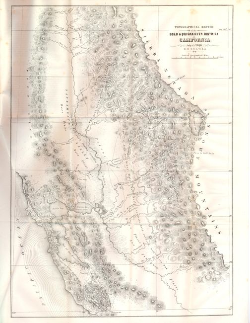
3) Topographical Sketch of the Gold & Quicksilver District California. (15.5 x 21.5") This map drawn by Edward Otho Cresap Ord is considered one of the most important maps of 1848. It shows in detail the area south of San Francisco Bay (the Quicksilver area), across the Sacramento Valley and San Joaquin Plains and east to Lake Tahoe (here called Mountain Lake). Notes indicate where gold was to be found throughout the region. An important Gold Rush map that was lithographed by P.S. Duval of Philadelphia. An exceptional example with a dark and early impression, fine paper and original margins. Would be fine except for one spot above title. (A)
These three maps rarely offered complete with the original report.
References: Wheat [Gold] 52; 51; 54; Wheat [TMW] #565; Schwartz & Ehrenberg p. 278-9.
Condition:
The report has some very light occasional foxing. See descriptions for condition of each map.