Subject: Midwest - Minnesota and Dakotas
Period: 1850-51 (circa)
Publication: Mitchell's New Universal Atlas
Color: Hand Color
Size:
16 x 13 inches
40.6 x 33 cm
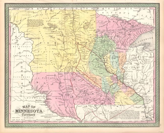
This well engraved map is an early example of Young's notable map, which is largely based on the works of Nicollet and Pope. This edition has county development limited to the extreme southern and eastern portions of the territory. The small settlement of Minneapolis shows up for the first time on this issue. The large region in the west is labeled Pembina, while the large southern area is named Blue Earth, this presenting the rarest configuration from this series of maps. Within Pembina is the large SALT WATER REGION and a notation discussing the brackish Minni Wakan Lake. A small area along the Minnesota River is Dakota Reserve, an early mention of the area's future name. Settlement is almost exclusively along the Mississippi River. Many Indian tribes are located, including the Assiniboine, Yanktonan, Chippeway, Mennomonees, Winebagoes, etc. Forts along the Missouri River include aux Cedres, Lookout, Pierre Choteau, Clarke, and Mandan (noted as the wintering place of Lewis and Clarke in 1804-05). Fancy titling and decorative borders. This detailed and interesting map documents the early stages of development of Minnesota and the Dakotas. At bottom is a description of the Sioux Treaty of 1851.
The area called Blue Earth comes from a translation of the Dakota Indian word Mahkato, meaning greenish or blue earth as they used the same word for blue and green. Pierre Le Sueur was a French explorer who arrived at the confluence of the Minnesota and Blue Earth Rivers in 1683 where he first saw the earth, concluding the color was from a rich deposit of copper ore. He returned to the Blue Earth area in 1700 and built the outpost Fort Le Huillier with the intent to mine the copper along the bluffs of the river. But the colored dirt turned out to be only clay and the mining operation was never pursued.
References:
Condition: A+
Beautiful example with strong impression and bright original coloring. The original margins have a trace of edge toning, still fine.