Subject: Eastern United States
Period: 1790 (circa)
Publication: Petit Atlas Modern
Color: Hand Color
Size:
7.3 x 9.8 inches
18.5 x 24.9 cm
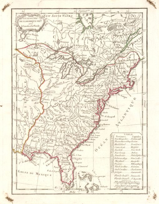
East and West Florida underwent several boundary and sovereignty changes during its history. The two regions were established in 1763 by the British colonial government out of land taken from France and Spain after the French and Indian War. Reasoning the newly acquired territory too large to govern, the British divided it into two new colonies separated by the Apalachicola River.
West Florida was based in Pensacola, and the colony included the part of formerly Spanish Florida west of the Apalachicola, plus the parts of French Louisiana taken by the British. Its northern boundary shifted several times over the years. East Florida has as its capital St. Augustine, which had been the capital of Spanish Florida.
Both remained loyal to the British crown during the Revolutionary War, and served as havens for Tories fleeing the Thirteen Colonies. In 1781 Spain invaded West Florida and captured Pensacola, leading Britain to cede both to Spain following the war. The ill defined boundaries led to a series of border disputes between Spain and the nascent United States known as the West Florida Controversy. Disagreements with the Spanish government led settlers along the gulf coast to declare the area the independent Republic of West Florida in 1810. The area was soon annexed by the United States, claiming the region as part of the Louisiana Purchase. The remainder of West Florida and all of East Florida were purchased by the United States in 1819 under the terms of the Adams–Onís Treaty. Florida Territory was formed as a result.
Attractive and early map of the United States that shows the western boundary of North and South Carolina, and Virginia and Georgia extending to the Mississippi River. A table in the Atlantic names the 13 states as organized in 1783 with their capitals. West and East Florida are delineated to show them as a part of the Spanish possessions of Louisiane with West Florida extending to the Mississippi River. The huge northwestern region is unnamed and unsettled but a few forts are located as is Detroit. The map locates numerous forts, Indian villages and good detail of early watershed knowledge. Small decorative cartouche at upper left. No. 26 along vertical neatline at lower right. Two distance scales.
References:
Condition: A
Very nice, dark impression on thick hand laid paper with original margins. Some old ink lettering in the four corners of blank margins, otherwise fine.