Subject: Western Hemisphere
Period: 1689 (dated)
Publication:
Color: Hand Color
Size:
23.5 x 17.5 inches
59.7 x 44.5 cm
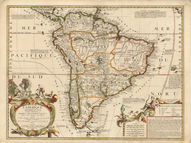
From 1681 to 1683 Vincenzo Maria Coronelli worked in Paris to construct a massive pair of globes for Louis XIV. During this time he had access to court documents including the manuscripts of La Salle. He also made the acquaintance of Jean Baptiste Nolin, who was the royal geographer. Upon his return to Venice in 1684, he became royal cosmographer of the Republic of Venice, and began compiling maps for his great atlas, the Atlante Veneto. He prepared two-sheet maps of both North and South America in 1688 for inclusion in this atlas, which was first published in 1691. In 1689 with the agreement of Coronelli, Jean Baptiste Nolin published these reduced single sheet versions in Paris. They include all the important cartographic advances of the larger maps, but different French-style cartouches.
The spectacular map of North America features California as an island on the Foxe model with two indented bays at top. A note near the peninsula of Agubela de Cato speculates on the location of the Strait of Anian. A major cartographic innovation is the depiction of the Rio Grande emptying into the Gulf of Mexico rather than the Gulf of California. Antoher influential feature (though incorrect) is the depiction of the Mississippi River, which is located too far west and flanked by a massive mountain range. This information for the Mississippi was based on reports from the La Salle expedition. The Great Lakes are shown quite accurately for the time, with Lake Ontario named Frontenac. The Chesapeake Bay is shown a bit too wide, and the fictitious Lake May is noted just south of the Appalachians, which are an isolated group of mountains rather than a long range. There are numerous notations on the map regarding explorer's travels. The decorative cartouche incorporates two horns of plenty that empty their contents of treasure into the waiting hands of a native and a European.
The equally impressive map of South America includes extensive annotations regarding explorations, along with the tracks of Jacques Le Maire's trek around Tierra del Fuego and into the Pacific in 1615-17. A notation at upper left discusses the favorable trade winds that were used by the Manila-Acapulco galleons. A smaller version of Lac de Parime is located on the equator with a notation questioning its existence. The Rio de la Plata emanates from the large Laguna de Los Xaraies, with a note attributing its discovery to Juan Diaz de Solis. The cartouche at lower right contains a key, scales and a lengthy annotation concerning the Papal Line of Demarcation, which split Brazil from the rest of South America, leaving Brazil to the Portuguese and the rest of the continent to the Spanish. The title cartouche features a particularly gruesome scene of cannibalism.
References: Burden #656.
Condition: A
A fine, matched pair with sharp impressions and original color. Faint toning overall with some professional paper restoration in the blank margins (mostly on the South America map).