Subject: Western Hemisphere - America
Period: 1661 (dated)
Publication:
Color: Hand Color
Size:
19.2 x 15.8 inches
48.8 x 40.1 cm
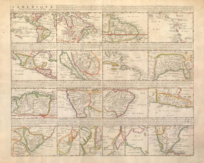
Pierre Duval's compilation of American maps is both rare and unusual. The sheet contains 18 individual maps of various parts of North and South America. The general map at top left is drawn from Duval's own folio map of 1655, which features the island of California, no Great Lakes, and a large Terre de Iesso stretching between Asia and North America.
There are eight devoted to North America; four of which are based on Sanson's maps of 1656 - Le Canada, La Nle. Espagne, Le N. Mexique, and La Floride. Burden's comparison with Sanson's maps leads him to believe that Duval's map may have preceded Sanson's Audience de Guadalajara or possibly were published concurrently, making this map of New Mexico actually the first devoted to the island of California. Interestingly, on the small map the island is presented on the Foxe model, while on the general map it is shown on the Briggs format. The four small maps along the center of the bottom row - La Virginie, La Nle. Holande, La Nle. Suede, and Le Nouveau Danemarq are extremely interesting because there are few contemporary maps devoted to these regions. The map of New Holland features the lower part of the R. del Nort (Hudson River). The map of New Sweden is the first map to focus on the Delaware River. The map of New Denmark depicts the Arctic region claimed by Denmark to the northwest of Hudson Bay, here labeled Mer Christiane.
The other maps on the sheet include two devoted to the West Indies, and seven regional maps of South America - La Guiane, La Castille d'Or, Le Perou, Le Bresil, Le Chili, Le Paraguay, and La Magellanique. It would be fascinating to do a comparative study of these maps similar to Burden's investigation of the maps of North America. This is the second state with the imprint of I. Lagniet added.
References: Burden #322.
Condition: A
Light overall toning with a professionally reinforced centerfold. There are some brown ink markings on verso.