Subject: Gulf of Mexico and Caribbean
Period: 1720 (circa)
Publication:
Color: Hand Color
Size:
40 x 23 inches
101.6 x 58.4 cm
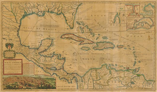
This large and incredible chart is filled with so much information, notes, place names and interesting configurations that it almost defies description. The map itself extends west to include the Rio Grande, south to northern South America, east to include the Bahamas and the Caribbean, and north to just show Charles Town. The rich silver mining area of Caouila (Coahuila) is shown in New Mexico. Louisiana occupies the entire Gulf Coast and is noted as being in Possession of ye French. Florida is depicted in the triangular form and is called the region of Lakes, Morasse's and Broken Land. Georgia extends west to the Apalaxy River and is labeled Carolina - English. Texas is not named, but the region is labeled Quelameloueches (a possible reference to the Comanche Indians) and is a Country full of Beeves. This region extends to name New Mexico, which itself is above New Leon in northern Mexico. An interesting notation describes the route used to transport cannons to Acapulco. Many details in the Caribbean Sea and Gulf of Mexico relate to the routes of Spanish galleons and there are many other notes on the Trade Routes to Spain. The lines of longitude show the number of hours difference from London. A large inset of Mexico City fills the left quadrant of the map and five smaller insets detail Havana, St. Augustine, Portobello, Cartagena and Vera Cruz. A dedication cartouche to Sir William Paterson is topped by a coat of arms. Paterson founded the Bank of England and was a prominent trader in the West Indies. He was also the main proponent of the infamous Darien scheme. Published by Thomas and John Bowles. Two sheets, joined, as issued.
References:
Condition: B
The map is toned overall and professionally backed with laid paper. There is minor loss along a couple of folds, but is overall attractive and stable.