Subject: Southwest United States & Mexico
Period: 1850 (dated)
Publication: Senate Doc. #81, 32nd Congress
Color: Black & White
Size:
10.8 x 22.3 inches
27.4 x 56.6 cm
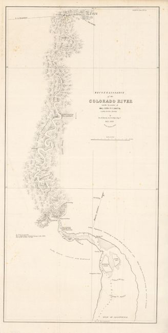
A provision of the Treaty of Guadeloupe Hidalgo that ended the war with Mexico gave the United States navigation rights in the Gulf of California and up the Colorado River. Lt. George H. Derby, Corps. of Topographical Engineers, was assigned the task to reconnoiter the mouth of the river and determine the navigability as far north as Camp [Fort] Yuma. Located at the confluence of the Colorado and Gila Rivers, Yuma was one of the great natural crossroads of the Southwest and Derby's map served to focus attention on the area just as throngs of gold seekers chose this route to California. The map locates Indian villages, landings, and conditions along the winding course of the river. A historically significant map that delineates the Colorado River from its confluence with the Gila River to its mouth in the Gulf of California. Wheat describes this map as "interesting and useful" and notes that it was the basis for cartography of that area until the Ives maps appeared a decade later in 1860.
References: Wheat (TMW) #668.
Condition: B+
Folding as issued. A few tiny spots that do not detract.