Subject: Ohio
Period: 180-1820 (circa)
Publication:
Color: Black & White
Size:
13.3 x 16 inches
33.8 x 40.6 cm
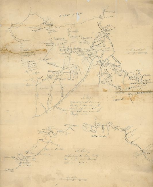
This manuscript map, drawn in blue ink, shows eastern Ohio and Western Pennsylvania in two maps. It appears to be an early 19th century hand drawn copy of the original created circa 1766 by Thomas Hutchins. Hutchins' map has a nearly identical title: "A Map of the Country on the Ohio & Muskingum Rivers Showing the Situation of the Indian Towns with Respect to the Army Under the Command of Colonel Bouquet". This map was one of the oldest drawings of the Ohio country, Thomas Hutchins rendered the top portion based on an earlier map he drew after he toured the area in 1762. Two years later, he drew the bottom portion while traveling with Colonel Henry Bouquet on an expedition from Fort Pitt into the Ohio country. The purpose of this copy is unclear, but based on its condition, folding and considerable wear, may have been a working map for a prospector, land seeker or perhaps an explorer further mapping the region. The date is based on the paper and writing style.
Thomas Hutchins was an American surveyor, mapmaker and the first "geographer of the United States." He was born in the colony of New Jersey in 1730. Prior to the American Revolution, Hutchins served in the British army and participated in the French and Indian War. During the Revolution, he served in the British Army, but in 1779 the British charged him with treason. Hutchins resigned his commission in 1780 and on July 11, 1781, Congress appointed him as "geographer of the United States." After the Revolution, Hutchins continued as a geographer, surveyor and mapmaker in the western frontier. He was given the job of plotting the land set aside for the Northwest Territory by the Land Ordinance of 1785. He laid out four of the Seven Ranges, which organized early settlement of the territory. Hutchins had previously visited and mapped portions of what is now Ohio, when he participated in Bouquet's Expedition in 1764.
References:
Condition: B
Separations on three folds, and a 4" tear from the left closed on verso with an old cloth repair.