Subject: Western United States
Period: 1873-1881 (dated)
Publication: Annual Report U.S. Geographical Surveys, U.S. Army
Color: Printed Color
Size:
22 x 16 inches
55.9 x 40.6 cm
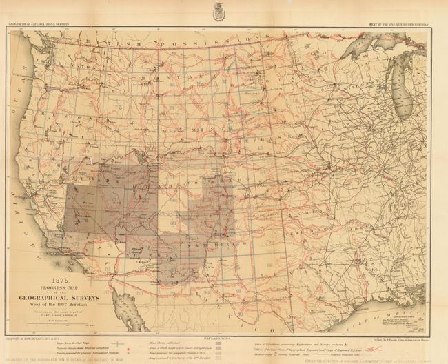
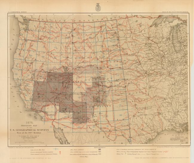
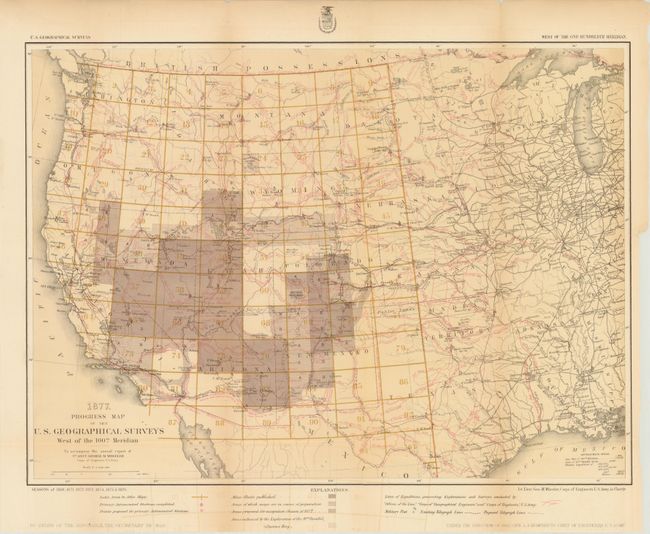
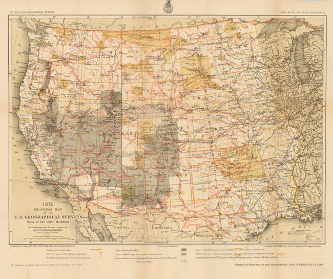
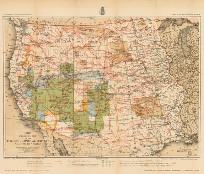
The first five maps are a remarkable set of Wheeler's Progress maps include the publication years 1875, 1876, 1877, 1879 and 1881. They present detailed representation of the various routes of western expeditions and the important surveys of King (40th parallel), Wheeler, Powell & Hayden. Among the details are the locations of occupied and abandoned posts, astronomical stations, signal service stations, telegraphic lines, and the routes of cattle droves and trains. It is a virtual tour de force of prior explorations and surveys with more information than is possible to include in this catalog description. Each was published in Lieut. Wheeler's Annual Report under the direction of Brig. Gen. A.A. Humphreys, Chief of Engineers. These progress maps are among the most interesting, informative and useful maps of the West. 1875: weak folds with some long splits and tape repair on verso (C+); 1876: one split and some tape repairs (B+); 1877: a couple tape repairs but generally clean and bright. A small, clean punch visible when held to light. (B); 1879: on thick paper. (A); and 1881: on thick paper, clean and bright but with two fold splits closed on verso. (B+)
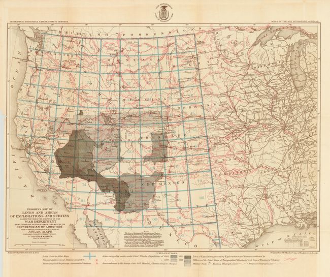
The expanded title of the sixth map is Progress Map of Lines and Areas of Explorations and Surveys … with an Index Illustration of a Series of Atlas Maps. This map was issued with the 1875 map mentioned above. It uses shading to indicate the Areas surveyed by parties under Lieut. Wheeler in 1869, 1871, 1872, and 1873; Area embraced by the survey of the 40th Parallel (Clarence King); other surveys prosecuted by Officers of the Line, the Corps of Topographical Engineers and the Corps of Engineers. Icons are used to indicate existing and proposed telegraph lines, Military Posts, Astronomical Stations, etc. The map uses a similar map to the above as its base. A few weak folds with tape repair on verso of one, but generally a nice example. (B+)
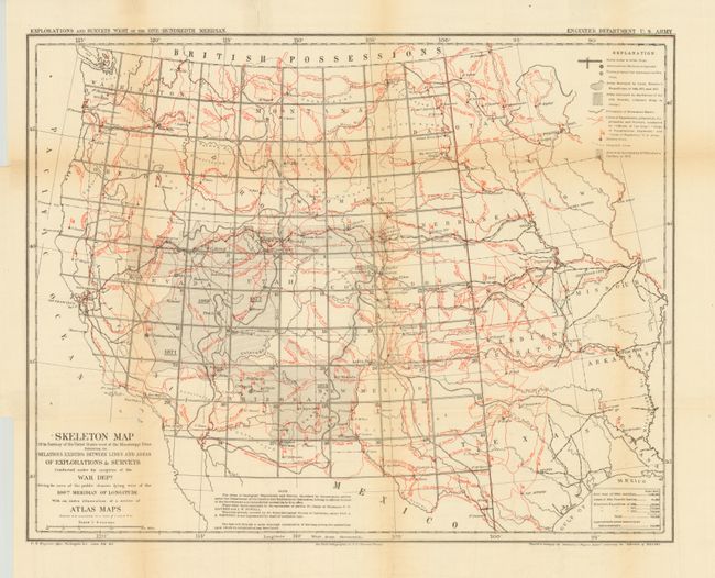
The Skeleton Map ... of Explorations and Surveys… was "Prepared to accompany the Preliminary & Progress Report concerning the Expedition of 1872 & 1873." This map presents similar information to the map immediately above, but in a slightly different style. Some weak folds and light toning on one fold. (B)
References:
Condition:
See description.