Subject: Western United States
Period: 1853-55 (dated)
Publication:
Color:
The Office of Coast Survey is the oldest U.S. scientific organization, dating from 1807 when Congress directed that a "survey of the coast" be carried out. By 1836, it was called the U.S. Coast Survey and in 1878, the name was changed to the U.S. Coast and Geodetic Survey. Today the Office of Coast Survey is a division of the National Oceanic and Atmospheric Administration NOAA.
The survey teams, composed of civilians as well as Army and Naval officers, charted the nation's waterways and produced a wide array of reports, survey charts, hydrographic studies of tides and currents, astronomical studies and observations, and coastal pilots. These charts are an important record of the changing nature of the nation's coastlines. In additional to coastal charts, the U.S. Coast and Geodetic Survey produced land sketches, Civil War battle maps, and the early aeronautical charts.
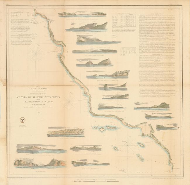
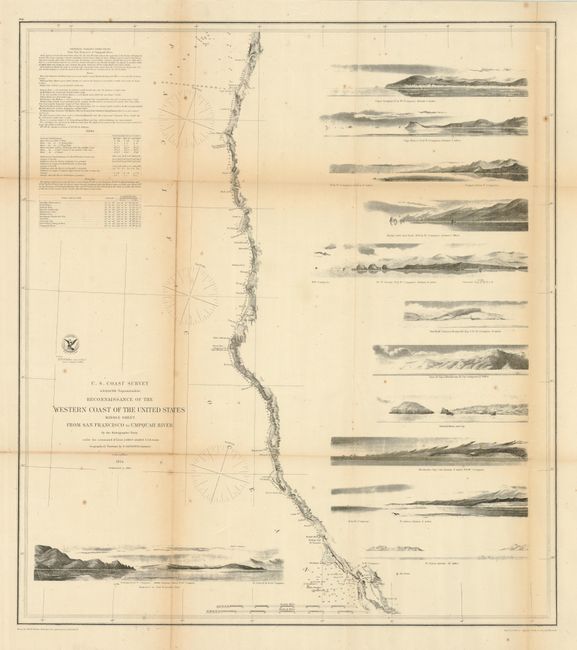
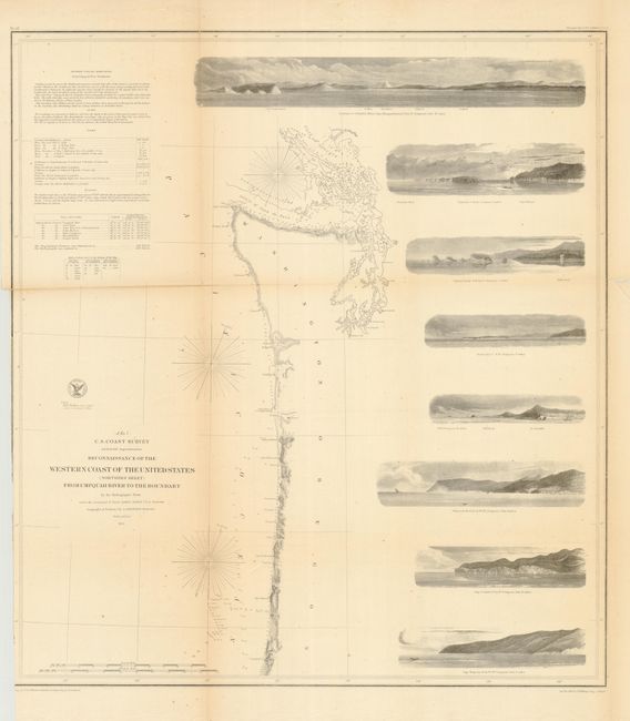
The first three are a complete set of the three larger coastal survey charts that cover the western coastline from San Diego to the border with Canada. They should not be confused with the slightly smaller, simpler charts that do not feature the large number of coastal views. Each is from the first official scientific reconnaissance of the Pacific coast and each outlines the coastal littoral, shows dangerous reefs and shoals, gives offshore bathymetric soundings, plus general and specific harbor and sailing instructions. Each measure approximately as given.
1) The first chart (No. 9) covers the region from the Mexican boundary to Point Reyes. The most impressive feature is the 17 views of entrances and promontories along this rugged coastline, among them Santa Barbara, Catalina Harbor, and the entrance to San Francisco Bay. One of the most desirable Coast Survey charts. Dated 1853, hand colored, (22.8 x 22"). Backed with archival tissue to support some weak folds, one with toning. Binding trim to neatline at lower half of left margin, as issued, with paper laid in to facilitate framing. (B)
2) The second, produced one year later in 1854, details the California and Oregon coast from San Francisco Bay to the mouth of the Umpquah River in the north. Major points included are Bodega Bay, Shelter Cove and Trinidad Bay in California, and the Klamath River, Crescent City, Port Orford, Cape Blanco and the Rogue's River in Oregon. With 11 views including Cape Mendocino and the Crescent City Light House. Black & white, (22.2 x 24.8"). Toned along folds and splits closed on verso with archival tape. Should be backed. (C+)
3) The third chart continues up the northern Oregon coast from the Umpquah River to the Straits of Juan de Fuca to include the full extent of Puget Sound. Names Cape Foulweather, Cape Lookout, Tillamook Head and False Tillamook, Cape Disappointment and Astoria at the mouth of the Columbia River, and Gray's Harbor. The seven large views include Cape Lookout, Destruction [Bay], and at the top the large "Entrance to the Columbia River, Cape Disappointment." This is the final map in the series, dated 1855. Black & white, (22.5 x 24.7"). Lightly toned on some folds. A few folds weak with archival tape on verso. Should be backed. (B)
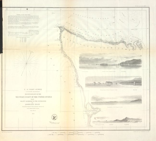
4) The last "Reconnaissance" chart details the entrance in to the Straits of Juan de Fuca to the entrance to Puget Sound, and south to Gray's Harbor. The four navigation views show Cape Flattery, Destruction Island, Sail Rock and Pt. Grenville. 1853, b&w, 17.6" x 14.5". Toned on folds with folds supported on verso with archival tape. (B+)
References: Heckrotte & Sweetkind #33; Schwartz & Ehrenberg, plt. #174.
Condition:
See individual descriptions.