Subject: Southern United States
Period: 1785 (circa)
Publication: Atlas Universel de Geographie Physique et Politique
Color: Hand Color
Size:
16.5 x 12.7 inches
41.9 x 32.3 cm
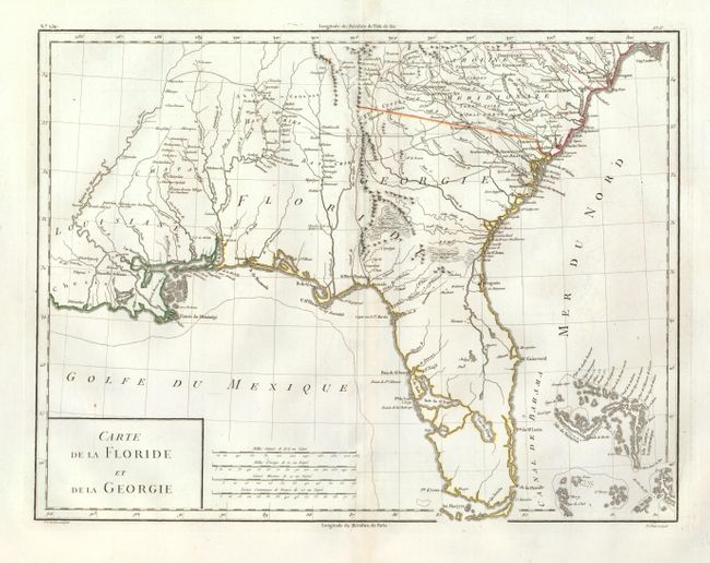
East and West Florida underwent several boundary and sovereignty changes during its history. The two regions were established in 1763 by the British colonial government out of land taken from France and Spain after the French and Indian War. Reasoning the newly acquired territory too large to govern, the British divided it into two new colonies separated by the Apalachicola River.
West Florida was based in Pensacola, and the colony included the part of formerly Spanish Florida west of the Apalachicola, plus the parts of French Louisiana taken by the British. Its northern boundary shifted several times over the years. East Florida has as its capital St. Augustine, which had been the capital of Spanish Florida.
Both remained loyal to the British crown during the Revolutionary War, and served as havens for Tories fleeing the Thirteen Colonies. In 1781 Spain invaded West Florida and captured Pensacola, leading Britain to cede both to Spain following the war. The ill defined boundaries led to a series of border disputes between Spain and the nascent United States known as the West Florida Controversy. Disagreements with the Spanish government led settlers along the gulf coast to declare the area the independent Republic of West Florida in 1810. The area was soon annexed by the United States, claiming the region as part of the Louisiana Purchase. The remainder of West Florida and all of East Florida were purchased by the United States in 1819 under the terms of the Adams–Onís Treaty. Florida Territory was formed as a result.
Handsome early map covering from South Carolina to Florida and the Bahamas and much of the lower Mississippi valley. The map depicts Florida during the period it was controlled by the Spanish and names East and West Florida. However, there are no engraved political divisions indicating the mapmaker's bias toward either the territorial claims of Spain or the United States. The map provides an excellent view of the Gulf Coast with a dramatically oversized Tampa Bay (Baie de St. Esprit), reflecting the limits of contemporary knowledge of the region. Numerous Indian villages are located and roads are shown connecting early settlements. In central Florida the furthest south settlements are Dest, Suliga and Allavatra. Locates New Orleans and Louisiana Territory. The Bahamas are also well delineated. Published by Chanlaire & Mentelle.
References:
Condition: B+
Near fine example with wide, original margins and grape cluster watermark. Faint toning at centerfold.