Subject: Colonial United States
Period: 1775 (published)
Publication:
Color: Black & White
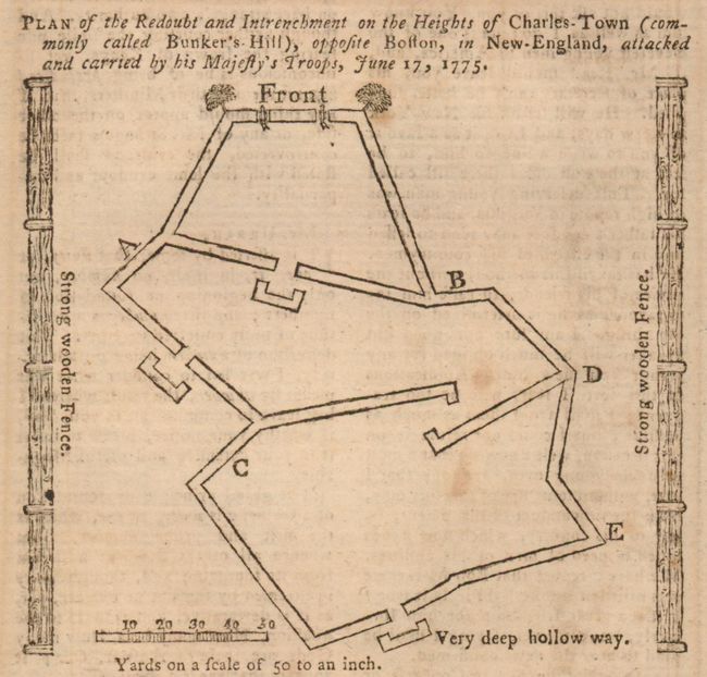
1. Plan of the Redoubt and Intrenchment on the Heights of Charles-Town (Commonly Called Bunker's-Hill), opposite Boston in New-England, Attacked and Carried by His Majesty's Troops, June 17, 1775, Gentleman's Magazine, 1775, 3.8" x 3.4". Simple plan of the walls, redoubt and entrenchments. Jolly, Gent-238. Lightly foxed.
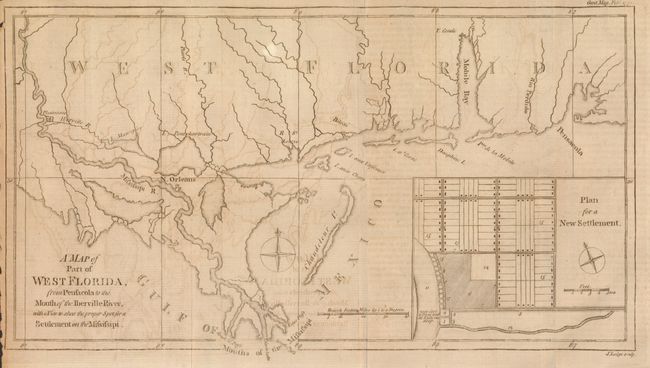
2. A Map of Part of West Florida, from Pensacola to the Mouth of the Iberville River, with a View to shew the proper Spot for a Settlement on the Mississippi, John Lodge, Gentleman's Magazine, 1772, 13.5" x 7.4", An interesting map featuring Mobile Bay and Fort Conde, New Orleans and Plantations on the Mississippi well north of New Orleans. Large inset "Plan for a New Settlement" shows much detail including docks along the river. This map was published in response to reports that the British government was considering the settlement of a colony on the banks of the Mississippi; the point suggested was near today's Baton Rouge. Jolly GENT-217; Sellers & Van Ee #1650. Offsetting.
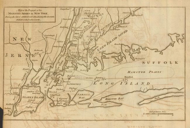
3. Map of the Progress of his Majesty's Armies in New York, During the Late Campaign Illustrating the Accounts Publish'd in the London Gazette, Gentleman's Magazine, 1776, 12.4" x 7.8" The December 1776 issue of this map adds additional battle information; the earlier edition (with a different title) was published in the October 1776 issue (Jolly GENT-248). Troop and battle deployments are clearly shown, including the recent actions around White Plains. It also shows additional towns and roads on Staten Island and in East Jersey. A fascinating Revolutionary War map designed to inform the British people on the progress of the war against the Colonies. Offsetting.
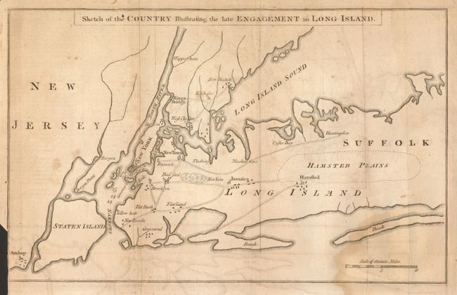
4. Sketch of the Country Illustrating the late Engagement in Long Island, Gentleman's Magazine, 1776, 12.5" x 7.8". This is the first edition, published in October 1776, of this map that shows the initial troop positions and battle activity of this important and early American Revolution battle. Troop and battle deployments are clearly shown. A fascinating Revolutionary War map designed to inform the British people about the American cause of independence. Jolly GENT-248; Sellers & Van Ee #1150. Offsetting, stain at lower right, close trim at binding trim.
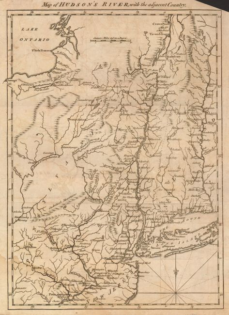
5. Map of Hudson's River, with the adjacent Country, Gentleman's Magazine, 1778, 8.4" x 11.6". Great little map from this British periodical that was designed to familiarize the magazine's readers with the location of the hostilities in the American War. This map illustrates the region of the Hudson and Delaware Rivers and the marches of the armies under the Generals Howe, Clinton and Burgoyne. It covers New York and New England as far east as the Connecticut River, south to include Philadelphia, and north to encompass Crown Point and Ticonderoga. A nice example of this desirable Revolutionary War map. Jolly GENT-257. Offsetting.
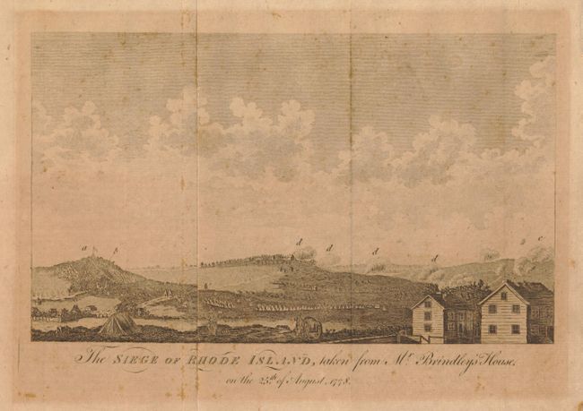
6. The Siege of Rhode Island, taken from Mr. Brindley's House, Gentleman's Magazine, 1779, 8.5" x 5". Contemporary engraved view of attacking forces during the Revolutionary War. The British occupied Newport in December 1776, and a long siege ensued lasting until October 1779 when the British evacuated Newport. This fine view shows numerous soldiers, encampments, and fires in the background. Published in the Feb. 1779 issue. Toned.
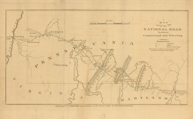
7. Map of the National Road Between Cumberland and Wheeling, John Melish, 11.2" x 5.8", circa 1820. From Melish's Description of the United States and Traveller's Directory. Split with old tape repairs on verso.
References:
Condition: B
Each is in need of cleaning or other minor restoration.