Subject: World
Period: 1605 (published)
Publication: Paulii G.F.P.N. Merulam Cosmographiae…
Color: Hand Color
Size:
19.8 x 11.8 inches
50.3 x 30 cm
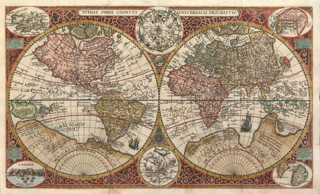
Engraved by Jan van Doetecum, this map is very similar to the one his father engraved for Petrus Plancius in 1590 (Shirley #177). The map is derived from Rumold Mercator's map with the improved shape for South America and inclusion of the Solomon Islands. Nova Zemla appears on this map below the distinctive polar islands of Mercator. And the northern landmasses are balanced by the huge southern continent. For this composition, Van Doetecum has added celestial hemispheres from Plancius' 1594 map and four inset maps of St. Helena, Iceland, Japan, and Ceylon all enclosed in the elaborate strapwork border. This map only appeared in one edition of Merula's work and is quite scarce.
References: Shirley #254; Walter #13.
Condition: B
Dark impression with original color and oxidation affecting the southern continent. This area has been skillfully restored using the leaf casting method for an invisible repair with the place names in facsimile.