Subject: United States
Period: 1890-1894 (published)
Publication:
Color: Printed Color
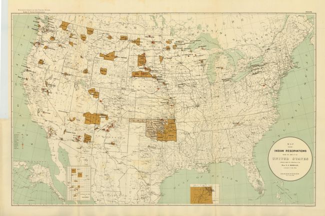
1) This large map of the United States focuses on the many Indian Reservations in the United States in 1894. The reservations are named and shown in dark brown overprinting. Inset maps are used where the reservation concentration prevents them showing well on the main map. Insets include Indian Territory, the Mission Indian Reservations in California, and the Territory of Alaska. An extensive legend locates Military Stations, Capitals, County Seats, Railroads, Indian Agencies, Training Schools, Boarding Schools, Day Schools and Contract Schools. Compiled under the direction of T.J. Morgan Commissioner of Indian Affairs and printed by Sackett & Wilheims Litho Co., New York. A large and very detailed map filled with information. (33.5 x 21") .
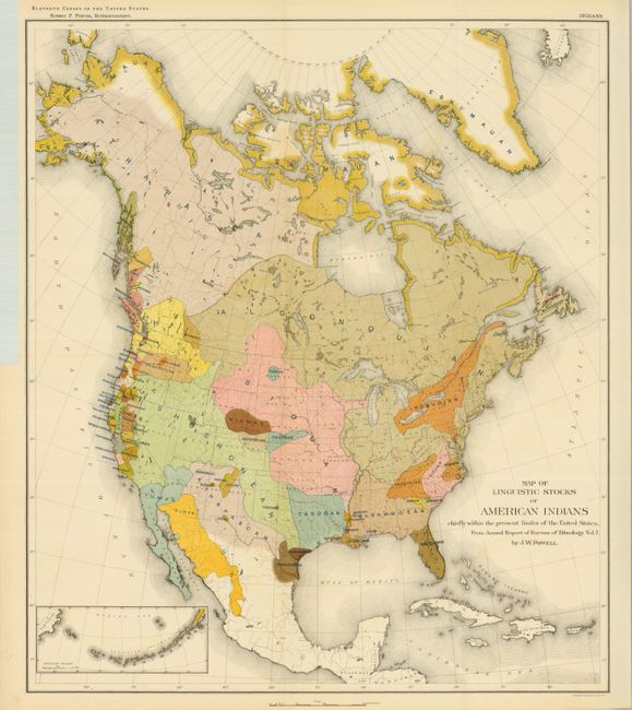
2) This colorful and useful map (17.5 x 20.3") is helpful in understanding the early relationships of the various Native American tribes. While covering most of North America, the focus of the map is the Native American tribes of the United States. A small inset shows the Aleutian Islands at lower left. Chromolithographed by the New York firm of Sackett & Wilhelms. The map was compiled under the direction of Henry Gannett, who established the geography program in the U.S. Census Office for the tenth (1880) census. In 1882 he created a similar program at the USGS, which became the Division of Geography in 1885 and produced the first topographic map sheets published in the General Atlas of the United States four years later. This is the increasingly rare issue of this map that was issued in the 11th Census, circa 1890-91.
These map were owned by Melvin R. Gilmore and carry his embossed stamp inconspicuously along the border of the maps at top right. Gilmore was a noted ethnologist and author who is best remembered for laying the groundwork for present-day analytical cultural ethnology. Interested in ethno botany, Gilmore studied and raised plants known to be grown by Native Americans. In 1914 he accompanied White Eagle, an elderly Pawnee Indian, to central Nebraska and recorded information about many abandoned village sites. Continuing his interest in the Pawnee, Gilmore conducted interviews in Oklahoma about Pawnee traditions. He was curator at the State Historical Society of North Dakota at Bismarck, on the staff of the Museum of the American Indian in New York (1913-1928), and was the curator of ethnology at the University of Michigan from 1929 to 1939. He authored several books and is noted for recording ritualistic ceremonies of the Arikara tribe.
References:
Condition: A
Folded as issued. First has a short binding tear repaired with archival tape.