Subject: Southern California and Southern Arizona
Period: 1849-69 (dated)
Publication:
Color: Black & White
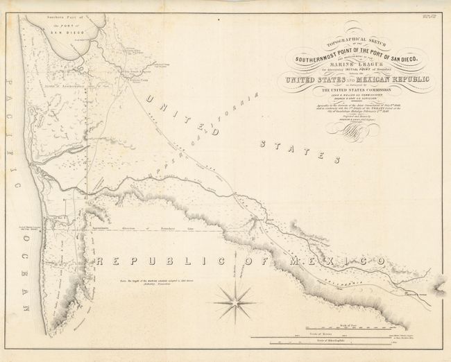
Topographical Sketch of the Southernmost Point of the Port of San Diego, and the Measurement of the Marine League for Determining Initial Point of the Boundary between the United States and Mexican Republic, by Andrew B. Gray, from Senate Ex. Doc 34, 1st Session, 31st Cong., 1849, (22.8 x 17.5"). This was the critical map of the Mexican Boundary Survey. Initial work had broken down over a Mexican demand that Mexico be given the port of San Diego, and the determination of the length of a league. It provides interesting detail in the vicinity of San Diego and anchors the border determination for this area. This map is full of information, including the new Camp Rough & Ready, which became a gold mining town and then seceded as a republic for about three months in 1850, until the neighboring towns started having 4th of July celebrations and they felt left out and rejoined the country. The map is visually very attractive with calligraphy title and a large compass rose. Marine leagues are described on the map as 5564 meters - the standard today. Surveyed by Andrew B. Gray, John B. Weller, Commissioner. Very nice example on bright paper with strong impression. A slight amount of foxing along portions of left edge. (A)
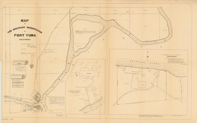
Map of the Military Reservation at Fort Yuma California, by Lt. George Wheeler, from Senate ex doc 25 48th Congress 1st Sess., 1869, (25 x 15.3"). Shows the fort in great detail at the convergence of the Gila and Colorado Rivers. Colorado City is shown across the river, as is the "Old United States & Mexican boundary." Large insets show the fort and depot with building level detail. Along with numerous notes this is a very complete picture of the fort in 1869. Issued folding, now pressed and professionally backed with Japanese tissue, toned along folds. (B+)
References: Map #1 - Wheat (TMW) #616.
Condition:
See individual descriptions.