Subject: Geography Books
Period: 1756 (dated)
Publication:
Color: Black & White
Size:
9 x 10 inches
22.9 x 25.4 cm
Jean-Etienne Guettard (1715-1786), a French scientist, was the first to attempt construction of geological maps beginning with a geological map of France and England in 1746. He was the first to announce the discovery of extinct volcanoes in Central France. He was also among the first to recognize the importance of organic remains as geological indicators and to prepare detailed figures and descriptions of them. His figures of fossil specimens included the first ever published illustration of a North American fossil.
His technique of creating geographical maps involved identifying the occurrences of minerals on a map using chemical symbols and then constructing “bandes” of rock formations having similar mineralogical characteristics. With reference to these maps, the distinguished 19th century Scottish geologist Archibald Geike sums up the importance of Guettard’s geocartographic insight: “These maps, as far as I know, were the first ever constructed to express the superficial distribution of minerals and rocks. The gifted Frenchman who constructed them is thus the father of all the national Geological Surveys which have been instituted by the various civilised (sic) nations of the Old and the New Worlds.”
Perhaps Guettard’s greatest achievement during his lifetime was the discovery of extinct volcanoes near Auvergne announced in “Memoire sur Quelques Montagnes de la France qui ont ete des Volcans”. This paper caused a sensation arousing much interest in Europe. The discovery would ultimately lead to one of the great scientific controversies of the last half of the eighteenth century and initial decades of the nineteenth century – the Vulcanist versus Neptunist debate over the origin of basalt.
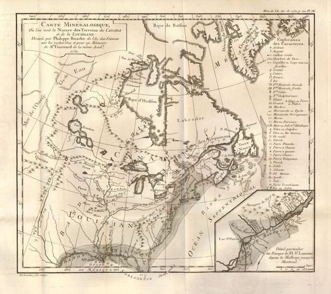
This volume includes four important maps, foremost is Guettard's geological map of North America as described first.
1. The Mineralogic map, showing the nature of the terrains of Canada and Louisiana, (12" x 10.5"),1852, is the first recorded attempt to produce a geological map of North America. In its production it is unclear whether Guettard visited North America, but most of his information was compiled from reports of French officers. The map provides primitive mineralogy indicating the location of belts of marl, clay, sands, schistose and metalliferous materials. Different signs and annotations are used to locate rocks and minerals between the Atlantic Coast and the Rocky Mountains. This map, drawn by Philippe Buache, is also of interest for it's inclusion of the cartographic curiosity "Mer de L'Ouest" (Sea of the West) which is shown as occupying part of western Canada (this feature also appears on Buache’s Planisphere Physique map also in this volume). This imaginary feature occupied a series of Buache's maps of North America and its derivatives, each showing the sea shrinking in size and prominence as exploration further west failed to prove its existence. This cartographic mystery lasted for a period of about five decades on certain maps.
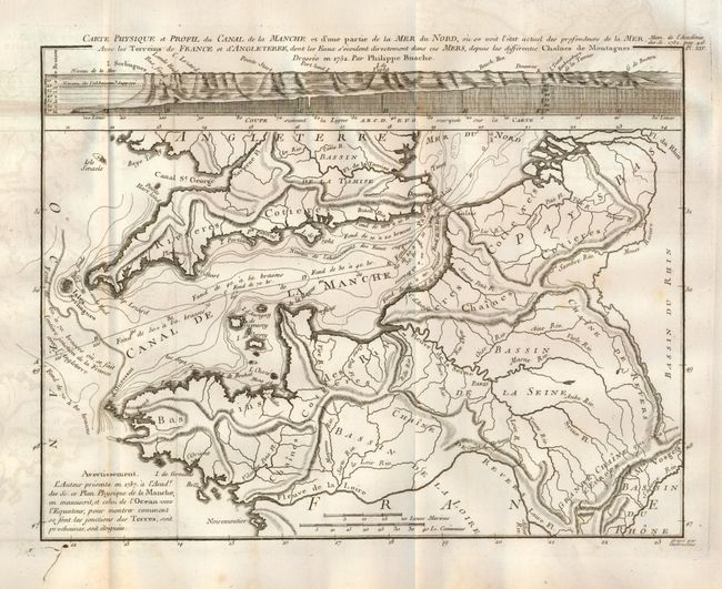
2. Of further importance in this volume is Philippe Buache’s influential Essai de Geographie Physique which includes the map Carte Physique et Profil du Canal de la Manche. For this effort at illustrating the bathymetry of the English Channel, Stefoff calls Buache "the first person to try to map the undersea world."
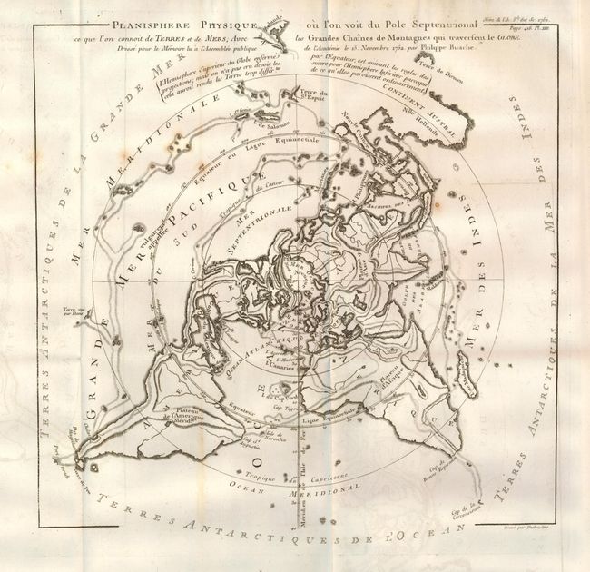
3. This volume presents the first appearance of Buache's Planisphere Physique ou l’on voit du Pole Septentrional ce que l’on connoit de Terres et de Mers, Avec les Grandes Chaines de Montagnes qui travertent le Globe, which shows Buache’s ideas of global structure involving continuous mountain chains separating major watersheds and ocean basins designed to illustrate the watersheds of the world. The map is presented on a North Polar projection. Strong hachure show the major mountain ranges and color is used to depict the watershed for each of the oceans. In North America there is a large Sea of the West and a nearly complete Northwest Passage. Australia is still shown with a conjectural coastline, making it considerably too wide. The continent connects to both New Guinea and Terre du St. Esprit (the Land of the Holy Ghost), discovered by Queiroz. Ref: Potter pp.178-9 (illus).
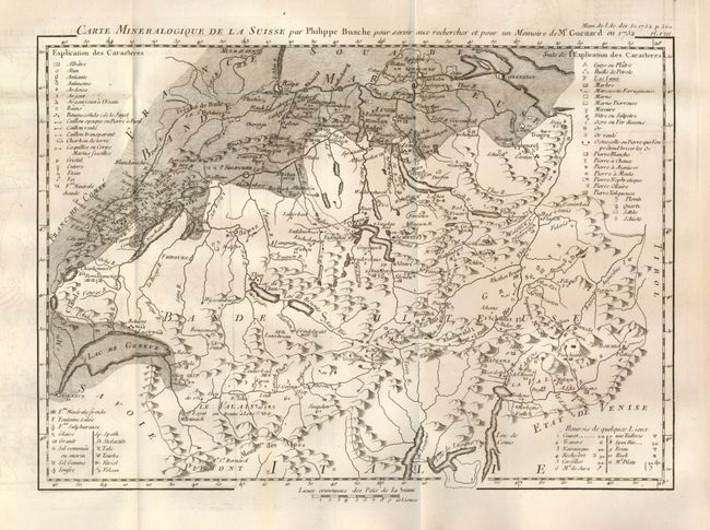
4. Guettard’s geological map of Switzerland, Carte Mineralogique de la Suisse, (13" x 9.3") is also the first geological map of that country.
The title page continues "Avec les Memoires de Mathematique & de Physique, pour la meme Annee." Paris: De L’imprimerie Royale, 1756. Hard bound in original brown leather boards, quarto, viii, 172 (Physique Generale), 638 (Memoires) pp. plus engraved frontis, and 21 folding engraved plates. Full leather with 5 raised bands, red and white marbled endpapers. All edges red.
References:
Condition: A
The four maps are near fine with dark, strong impression that have left a ghost of offsetting and the occasional light foxing spot. Binding is tight and pages are remarkably clean and bright. Toward center are a few pages with small physical bump at top edge. Covers with some wear to edges and two small areas of worming on spine.