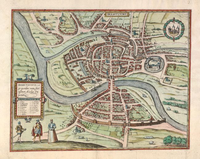
Subject: Bristol, England
Period: 1588 (circa)
Publication: Civitates Orbis Terrarum
Color: Hand Color
Size:
17.3 x 13.4 inches
43.9 x 34 cm
Braun & Hogenberg's Civitates Orbis Terrarum or "Cities of the World" was published between 1572 and 1617. Within the six volumes, 531 towns and cities were depicted on 363 plates, providing the reader with the pleasures of travel without the attendant discomforts. Braun wrote in the preface to the third book, "What could be more pleasant than, in one's own home far from all danger, to gaze in these books at the universal form of the earth . . . adorned with the splendor of cities and fortresses and, by looking at pictures and reading the texts accompanying them, to acquire knowledge which could scarcely be had but by long and difficult journeys?" Braun and Hogenberg incorporated an astonishing wealth of information into each scene beyond the city layout and important buildings. The plates provide an impression of the economy and prominent occupations, and illustrate local costumes, manners and customs.
This is a beautiful plan of the important trading city of Bristol with its suburb of Redcliffe in the foreground. It was taken from William Smith's rendering in 1568. In Old English the name Brycgstow means "the place at the bridge" and the large bridge spanning the Avon River is noted in Braun's description of the city; "Both parts of the city are linked by a stone bridge lined with buildings on both sides, so that one doesn't notice when going over the bridge that it is one." Bristol's location near the Bristol Channel and protected from the stormy Atlantic, led to its status as an important fishing port and embarkation point for many voyages to the Americas. The plan shows three people in the foreground attired in Elizabethan dress, and above them is a cartouche containing the title, Brightstowe, vulgo, quondam Venta, Florentissimum Angliae Emporium, and a numbered key to 15 important points within the map. French text on verso.
References: Fussel p. 204.
Condition: A
The centerfold has been expertly reinforced and a couple of short tears in the blank margins have been repaired.