Subject: Minnesota
Period: 1834 (published)
Publication: Narrative of an Expedition Through the Upper Mississippi River to Itasca Lake
Color: Black & White
Size:
13.3 x 20.3 inches
33.8 x 51.6 cm
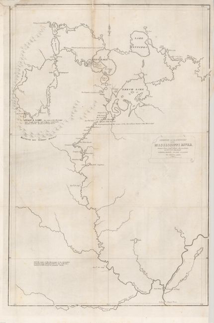
This very scarce map was drawn from Lieut. Allen's observations taken during this important expedition that established Lake Itasca as the source of the Mississippi. It shows an interconnecting chain of lakes and waterways ending at Lake Itasca with an adjacent notation stating the lake is "the source of the Mississippi river _ length from the gulf of Mexico 3,160 miles elevation 1500 ft - Reached 13th July 1832." The map locates trading posts just north of Lake Winnipeg and on Leech Lake and an Indian village on Leech Lake, otherwise there are no settlements noted. This earlier edition should not be confused with the smaller and more common map published by Schoolcraft in his History of the Indian Tribes...
Schoolcraft joined General Cass' expedition as the official topographer. Cass was charged with exploring the Northwest with the intent of finding the source of the Mississippi river, to "obtain a more correct knowledge of the names, numbers, customs, history, condition, mode of subsistence, and dispositions of the Indian tribes," to survey the topography of the country and investigate the regions mineral wealth and "to purchase from the Indian tribes such tracts as might be necessary to secure the United States the ultimate advantages to be derived from them."
References:
Condition: B
On thin hand laid paper. Issued folding but now flattened with a split on one fold line at right edge, closed on verso with archival tape and another closed with a paper repair. One fold with light toning.