Subject: World
Period: 1720 (circa)
Publication:
Color: Hand Color
Size:
38.7 x 22.5 inches
98.3 x 57.2 cm
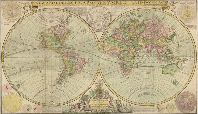
This very large, impressive world map is one of the first to record prevailing wind directions based on scientific observation. It was designed for a British public interested in maritime exploration and commerce and thus to encourage subscriptions for his New and Complete Atlas. In North America, California is shown as an island, a prominent River of the West is "laid down according to the Baron Lahontan's discoveries," and most of the Arctic is labeled "Parts Unknown." In northeastern Asia, Iesso (Hokkaido) is shown to be part of Siberia with Companys Land lying just offshore. Only the western and northern coasts, and a bit of Diemens Land, are shown in Australia. Surrounding the hemispheres are a variety of astronomical diagrams, including representations of the planets, the moon, a north polar projection, and the solar systems theories of Ptolemy and Copernicus. The title is enclosed in a banner-style cartouche at top, and at bottom is a large dedication cartouche to George I. Of particular interest is the vitriolic attack on Moll's competitors, particularly French cartographer Nicolas Sanson (whose maps have been condemned and found to be notoriously false). Moll goes on to claim the Dutch maps are inaccurate and often illegal piracies. Printed on two sheets, joined as issued.
Herman Moll was an engraver, geographer and bookseller of Dutch origin who settled in England in 1678. He engraved maps for a number of cartographers including Moses Pitt and Philip Lea before publishing his first atlas in 1710. Moll was highly astute, both politically and commercially, and through his extensive connections he was able to compile many important maps and atlases. His large-scale maps include some of the most famous 18th century maps of America, including the Beaver and Cod-Fishery maps, nicknamed for their decorative cartouches.
References:
Condition: B+
There is some minor soil, but overall very good. The old color is heightened with gold in the dedication cartouche. Narrow, but adequate margins, as issued. There is some professional repairs of minor insect damage and cracks in the map corners, now invisible except when held up to a strong light.