Subject: Hawaii
Period: 1897-1902 (dated)
Publication:
Color: Printed Color
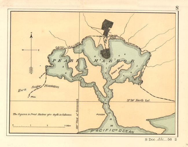
1) Pearl Harbor, 1901, Senate Document 231, 56th Congress 2nd Session, 10 x 7". Small map details the full extent of the harbor including its outlet to the Pacific Ocean. Soundings, with in the harbor, are in fathoms. Locates Pearl City in a street grid pattern. Locates the Oahu Railway, the Ewa Sugar Plantation with a mill, Ford's Island, Puuloa and the road to Honolulu. Fully colored with the lands in ochre and waters in blue. Very nice near fine example that is backed with archival tissue.
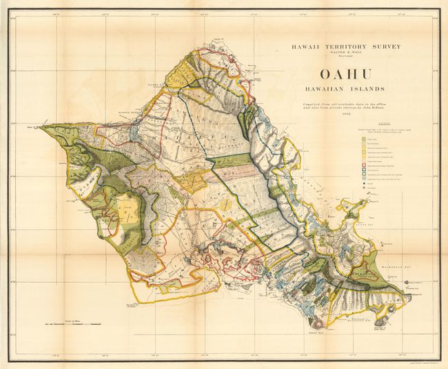
2) Oahu, 1902, Hawaii Territorial Surveys, 33 x 27". A brilliantly colored and detailed map of Oahu with much information on pineapple and sugar plantations, homesteads, public lands, Crown lands and public buildings. The areas of Diamond Head, Koko Head and Kailua Bay are described, as well as the Cocoa-Nut Grove on Maunaloa Bay, complete with tiny coconut trees. Hawaii's monarchy was overthrown in 1893, and this map was prepared for the Governor's Annual Report of 1906. The governor at this time was George R. Carter. Compiled by John M. Donn "from all available data in the office and also from private surveys." Issued folding, now backed with archival tissue to support folds. Toned on some folds, more so at one. (B+)
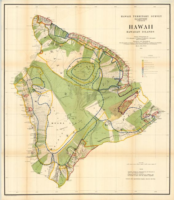
3) Hawaii, Hawaiian Islands, Hawaii Territorial Surveys, 1901, 32 x 36". This large and beautifully lithographed map was surveyed by W.D. Alexander and Walter E. Wall. With terrific detail at a scale of about 3 miles per inch. Ringing virtually the entire island are roughly 400 strips of land with the owner's name. These lots are locally called ahupua'a and are the basic land division in Hawaii. They usually run from the ocean to the mountains, as can be seen here. Contour lines are drawn in red at 300 ft. intervals. Extensive legend uses color and line to delineate the approximate area of Public Lands, Homestead Settlements Tracts, Grazing Lands, Pineapple Lands, Sugar Plantations, Forest Reserves, and wet lands consisting of rice and taro. Schools and post offices are shown by colored circles. The primary triangulation was accomplished by Alexander, C.J. Lyons, J.S. Emerson, J.M Lydgate and E.D. Baldwin. A very handsome and uncommon chart of the island. Issued folding, not backed with archival tissue. A little fold toning. (B+)
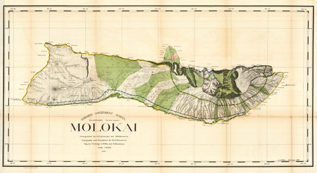
4) Molokai, Hawaii Territorial Surveys, 1897, 48 x 25". First edition of this large map produced by W.D. Alexander, the Surveyor-General. It is difficult to imagine a more detailed map of the island - topography, watershed, villages, land grants, coastal detail, lava flows, property owners - it's all here. At the turn of the century numerous valleys supported cattle ranches. On the northern exposure can be seen an area of about six square miles dedicated to a leper colony of about 100 souls. It was established in 1866 and was considered one of the most remarkable institutions of its kind in existence. Triangulation by Alexander and M.D. Monsarrat, who also did the boundaries and topography. The map was drawn by F.S. Dodge, C.J. Willis, and S.M. Kanakanui. Issued folding, now backed with archival tissue. A little fold toning. (B+)
References:
Condition:
See individual descriptions.