Subject: Western United States
Period: 1850 (published)
Publication: New Universal Atlas of the World
Color: Hand Color
Size:
13 x 15.5 inches
33 x 39.4 cm
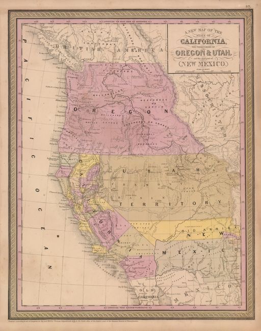
This is a great map of the western territories and the new state of California from this superb series of maps originated by Samuel A. Mitchell in 1846. Wheat states this map is up-to-date in naming the counties in California and it still gives a few place names in the Gold Regions but has removed the label "Gold Regions." The map carries the copyright notice 1850 but was published in 1852. Wheat also notes the depiction of the Great Basin is outdated and the new Mormon settlements do not yet appear. Oregon Territory takes in all of present day Washington and Idaho. The huge and newly formed Utah Territory covers the region labeled Fremont Basin, and stretches from the California border to just past the Rocky Mountains. New Mexico Territory (also formed in 1850) encompasses parts of present-day Colorado and Arizona with its southern boundary on the Gila River in a pre-Gadsden Purchase configuration. In the Pacific Northwest there is no sign of Portland, but Lima is shown across the river from Oregon City, Doctor Whitman's is shown upriver from Fort Walla Walla, and two Presb[yterian] missions are located on the Koos Koos Kee River (Clearwater River) with a Canoe Camp of Lewis & Clark located between them.
References: Wheat (TMW) #756.
Condition: B+
The map has full margins and good impression with slightly oxidized color. Margins with some soiling or toning and a few spots or stains in map mostly in Oregon.