Subject: United States & Mexico
Period: 1811 (dated)
Publication: Essai Politique sur le Royaume de la Nouvelle Espagne
Color: Black & White
Size:
28.5 x 16.6 inches
72.4 x 42.2 cm
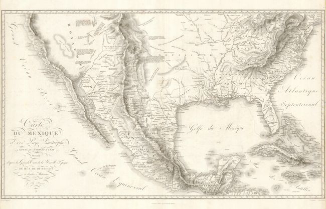
This is one of Alexander von Humboldt's important early maps of the Southwest. It covers the southern United States and Mexico and also includes the Bahamas, Cuba and Jamaica. The focus of the map however is the Viceroyalty of New Spain, which included Texas, Louisiana, New Mexico and California. While residing in Mexico City in 1804, Humboldt searched the Spanish and Mexican archives for geographical information that he compiled into his maps of the region. This map is often overshadowed by its companion map from this book, the Carte de la Nouvelle Espagne, which focuses on a smaller region with greater detail. Nonetheless, this is still a very scarce and important contribution to the cartographic history of North America. Drawn by Jean Baptiste Poirson and engraved by Barriere and Aubert.
References: Cohen pp. 100-101; Wheat #275.
Condition: B+
There is some light soil and faint foxing in the map. Narrow side margins ( 1/8") as issued. Fold separation in top margin has been repaired.