Subject: Oklahoma
Period: 1901-1905 (dated)
Publication:
Color: Printed Color
This lot is a great collection of Indian Territory related maps. All are folding as issued. Includes:
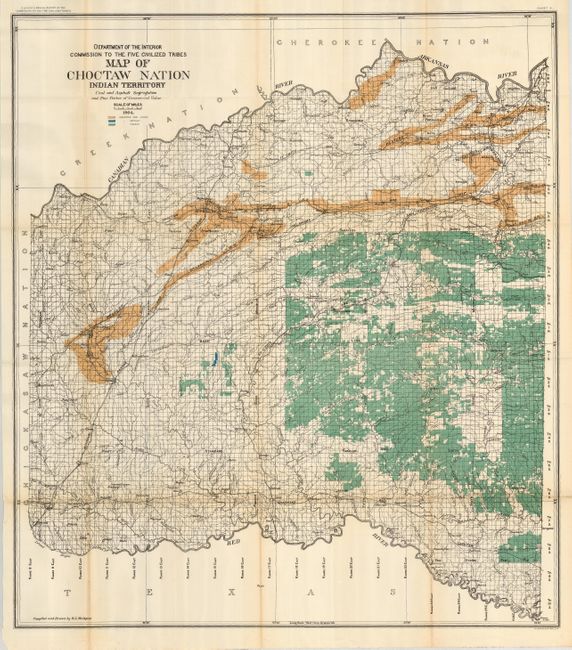
1) Map of Choctaw Nation Indian Territory, by R.L. McAlpine, from Eleventh Annual Report of the Commission to the Five Civilized Tribes, 1904. (32.5 x 37") This interesting and colorful map shows coal leases per the Choctaw and Chickasaw Agreement of 1898 along with the names of lessees in a table under the title. Legend uses color to locate coal, timber and asphalt. Also provides a detailed view of the rivers and creeks, railroads and towns. Compiled and drawn by R.L. McAlpine. Some light fold toning (B+).
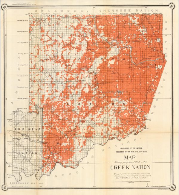
2) Map Showing Progress of Allotment in Creek Nation…April 1st, 1899 to June 30th, 1901, by C.H. Dana, Department of the Interior, Eighth Annual Report of the Commission to the Five Civilized Tribes. (24 x 25.5") This map uses orange overprinting to show tracts of land allotments. Centered on Kmulgee, the map is highly detailed at a scale of four miles per inch. The map covers the area between Muskogee in the east, Econtuchka to the west, and Tulsa in the north. All surveyed townships are noted, plus creeks and rivers, villages and small towns, missions, foot trails, wagon roads, and railroads. Folding as issued with some toning at one fold with split closed on verso with archival tape. (B+)
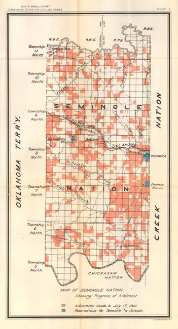
3) Map of Seminole Nation Showing Progress of Allotment. Eighth Annual Report of the Commission to the Five Civilized Tribes, 1901. (10 x 19") Similar to the above map, this map uses orange overprinting to delineate allotments completed to July 1st, 1901. Centered on Heliswa, the map names Mekusukey Mission, Econtuchka, Wewoka, Sasakwa and Emahaka Mission. Blue overprinting is used to indicate lands reserved for town sites and schools. Bordered on the west by Oklahoma Territory. (A)
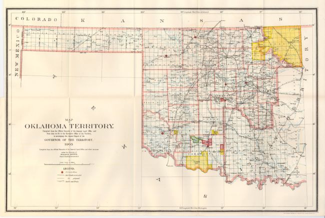
4) Map of Oklahoma Territory, General Land Office, Annual Report of the Governor of the Territory. 1905. (22 x 14.3") This map was compiled from the official Records of the General Land Office by the Territorial Governor under the direction of Frank Bond. It is an attractive and colorful map with great attention paid to detail, including railroads constructed and proposed, as well as roads and trails. The map covers present day western Oklahoma including the panhandle, but the portion in the southeast is Indian Territory. Land Offices are located at Woodward, Alva, Enid, Guthrie, Kingfisher, Ft. Reno, Mangum and Lawton. Overprinted colors are used to locate Indian Reservations, Grazing Land and Military Reservations. (A+)
References:
Condition:
See individual descriptions.