Subject: Nevada
Period: 1935-1958 (dated)
Publication:
Color: Printed Color
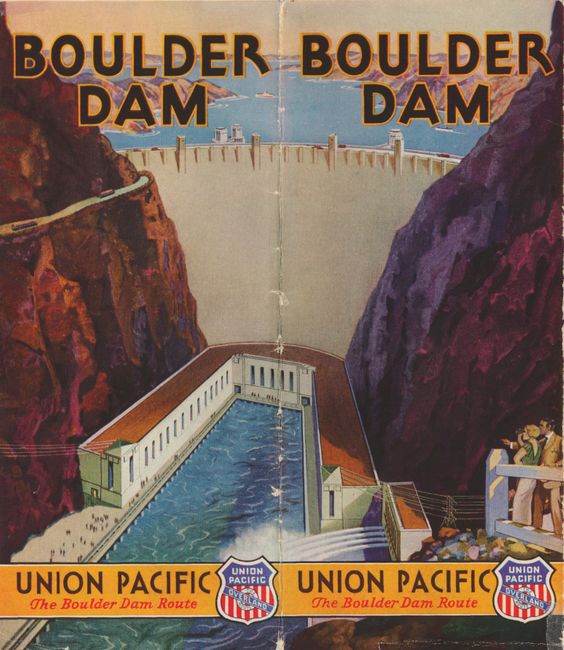
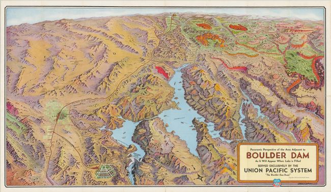
The first is a great example of pictorial bird's-eye-style maps that were used for advertising and publicity in the early part of the 20th century. This colorful perspective map covers the region serviced by the Union Pacific Railroad, from Salt Lake City (shown on the distant horizon) down to Boulder City, which appears to be larger than Las Vegas. It has a great depiction of Boulder Dam including a small portion of Black Canyon and shows water spraying from the turbine generator outlets. Steamships (!) are shown in Lake Mead. The map also includes the Grand Canyon, the National Parks of Bryce and Zion, Cedar Breaks Nat. Monument, and more. The route of Union Pacific Tours is shown along the north rim of the Grand Canyon where the Union Pacific Grand Canyon Lodge is prominently located. This striking image was drawn by Gerald A. Eddy of Los Angeles and published by the Boulder Dam Service Bureau, Boulder City. Dated 1935. The verso is filled with information for the tourist including photographs taken during the dam's construction, a road map of the west and an early photograph of Las Vegas that is amazing. Self folds into covers showing Boulder Dam drawn and titled in Art Deco style. Drawn by Gerald Eddy, 1935, 30" x 16.8". Near fine with no significant flaws (A).
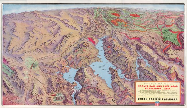
The second map is Panoramic Perspective of the Area Adjacent to Hoover Dam and Lake Mead Recreational Area, also by Gerald Eddy, dated 1948, 30 x 17". The map is identical to the former but has later pictures and information on the verso. Self folds into pictorial showing a couple in the foreground of the dam. Also near fine (A).
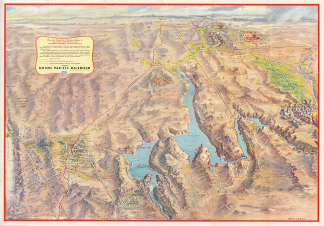
The third map is Panoramic Perspective of the Area Adjacent to Las Vegas-Hoover Dam and Lake Mead Recreational Area, again by Gerald Eddy, dated 1958, 30 x 20.8". This is another pictorial bird's-eye-style map but updated to the late 1950's. It shows the same area, also extending to show Salt Lake City, depicted by the Mormon Temple, on the far horizon. In the first two maps Las Vegas is shown as a small town, but here the resort town has grown significantly. Major roads are named as are many casinos along the strip including the Stardust, New Frontier, Dunes, Sands, Flamingo, the Sahara, and the Fremont Hotel in downtown. Nellis Air Force is shown north of the city. Filled on the verso with colorful photographs and a very early depiction of the famous welcoming Cowboy that came to symbolize the marketing and promotion of Las Vegas. Self folds into covers with photograph of downtown on Fremont Street showing the Las Vegas, Overland, and Fremont hotels, the Monte Carlo and Hotel Sal Sagev. Also near flawless (A). Together they form a wonderful time capsule covering the development of the area and most importantly the transformation of Las Vegas from a quite frontier town to bustling party town.
References:
Condition: A