Subject: Tennessee
Period: 1866 (published)
Publication:
Color: Hand Color
Size:
24.5 x 17.3 inches
62.2 x 43.9 cm
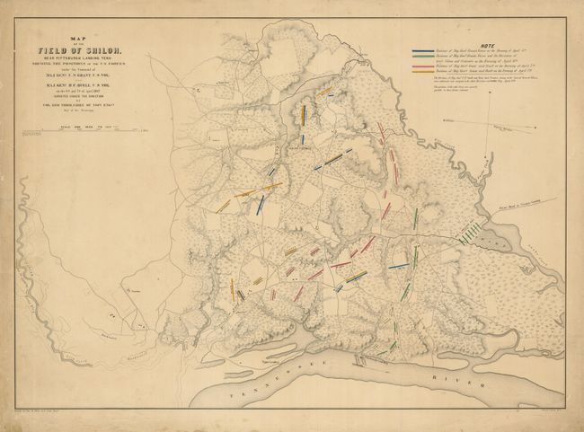
This rare, separately issued Civil War battle map, details the famous Battle of Shiloh, also known as the Battle of Pittsburgh Landing. The title continues "Surveyed Under The Direction Of Col. Geo Thom. Chief of Topl. Engrs. Dept. of the Mississippi." The legend uses hand coloring to locate the positions of forces for Generals Grant, Nelson, and Buell during four distinct periods of the battle from the morning of April 6th to the evening of the 7th. The map presents excellent information on a scale of 1200 feet per inch showing vegetation, topography by hachure, rivers and creeks, individual homes, mills, and villages. Locates the River Road to Crump's Landing; Pittsburgh Landing; Purdy Road; Shiloh Church; Hamburgh Road; two hospitals; the Corinth Road, and more. Drawn by Otto H. Matz, Asst. Topl. Engr., and lithograph by Julius Bien, New York. The example of this map in Rumsey's collection (Stephenson #436) is identical in size and detail except on the Rumsey example the final line in the title "Dept. of the Mississippi" is in manuscript, the position of the two gun boats at Pittsburgh Landing is slightly further upstream, fences are shown, and the lithography was done by Chas. Robyn & Co. cor. Chestnut and 3d St, St. Louis Mo.
References: Rumsey #3658; Stephenson #437.
Condition: B+
The map image is very good, but the margins have several short tears, soiling, foxing and a crease across one corner.