Subject: Colonial South
Period: 1707 (circa)
Publication: Reysen Na Oost En West-Indien
Color: Black & White
Size:
9 x 6 inches
22.9 x 15.2 cm
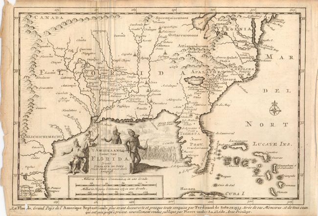
This interesting copper engraved map is based on Sanson's map of 1657. It covers the region from Texas to Chesapeake Bay, with many place names noted. The British colonies of Carolina and Virginia are shown east of the Appalachian Mountains, with the rest of the western part of the map named Florida. Lac Erie is shown considerably south of its actual location and the river systems are totally incorrect. A spurious north-south mountain range stretches through the central plains. Texas is labeled Terlichichimechi and the Florida Peninsula is named Tegesta Prov. A large title cartouche takes up the Gulf of Mexico with a scene of Ferdinand de Soto discussing his expedition with a group of Native Americans. Second title below map is "La Floride, Grand Pays de l'Amerique Septentrionale…par Ferdinand de Soto en 1534…"
References: Cumming (SE) #142.
Condition: B+
Some toning along folds and one fold with lazy creases. At lower left is a small worm hole in the lower title to affect the "i" in Floride.