Subject: New England
Period: 1871 (dated)
Publication:
Color: Hand Color
Size:
4.5 x 6.8 inches
11.4 x 17.3 cm
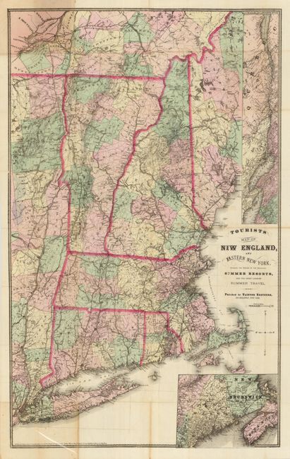
This rare publication contains the folding "Tourists Map of New England, and Eastern New York, Showing the Region of the Principal Summer Resorts, and the Great Lines of Summer Travel," copyright dated 1869 (published 1871), by Taintor Brothers, New York, 24" x 38". This hand colored map shows the entire Northeast with insets "Map of Niagara and St. Lawrence Rivers" and a second one showing the continuation of Maine with part of Nova Scotia and New Brunswick. Hardbound in original plum-colored cloth, edited by Charles L. Norton, New York: Taintor Brothers, 1871, first edition, 16 mo., 190 pp. plus frontis view of Newport, unnumbered advertisement facing page at p. 92, and the large folding map in pocket. This rare tourist guide was issued soon after the Civil War. No sales records or references located. OCLC locates only 12 original 1871 dated copies at libraries.
References:
Condition: B
Fold splits at many fold intersections of map. The map is delicate and should be professionally backed to stabilize the folds. Spine sunned, page edges brittle due to poor paper quality with some pages detached and having old tape repairs.