Subject: United States
Period: 1858 (dated)
Publication:
Color: Hand Color
Size:
17.3 x 10.5 inches
43.9 x 26.7 cm
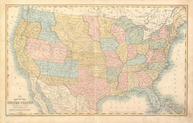
This map was published to capture the best combination of western territorial borders seen on any map. It includes the important Confederate Territory of Arizona that was created under General Baylor. Earlier editions contained the inset "No. 6 Map of the Gold Region of California" but it is removed here so Arizona is clearly visible. Oregon has just attained statehood surrendering its eastern territory leaving Washington extending to the Continental Divide in its invented "L" configuration. Dacota Territory is between Minnesota and the Missouri River. The huge Nebraska Territory borders Washington at the Continental Divide and Dacota. It touches an oversized Kansas that, with Utah, contains portions of the future Colorado. The Gold Region is in Kansas just southeast of Denver and adjacent to Cherry Creek. Utah is at its largest, filling the region from California to Nebraska Territory and Kansas along the Continental Divide. A note states the length of the Overland Mail Route from St. Louis to San Francisco is 2765 miles. Dated 1858 but published circa 1861-62. A fascinating Civil War period map.
References:
Condition: B+
Very nice example considering it was a school map. Near fine less some soiling at lower right corner and lower part of centerfold slightly worn.