Subject: United States
Period: 1826 (dated)
Publication:
Color: Hand Color
Size:
29.5 x 19.8 inches
74.9 x 50.3 cm
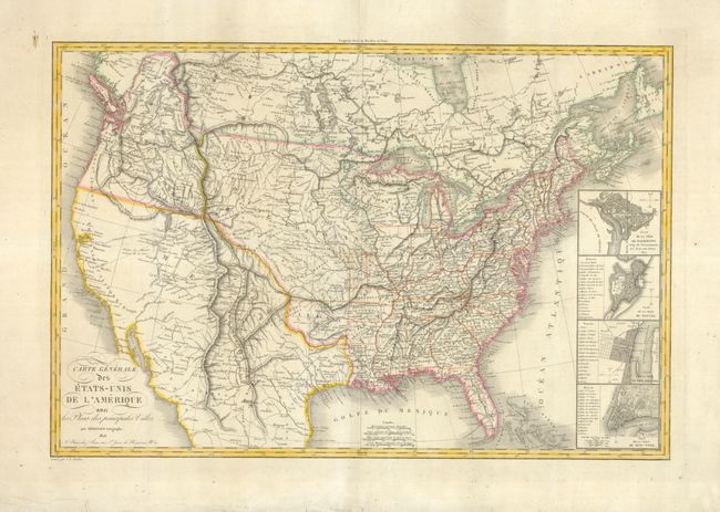
The United States and Great Britain established in 1818 joint claim over the Oregon Territory - the region north of Spanish controlled Upper California up to the southern boundary of Russia's Alaska Territory at North latitude 54°40'. By the late 1830's this arrangement was beginning to fall apart.
In the 1840's the expansionist Democrats, including their 1844 presidential candidate, James Polk, claimed the entire region for the United States. Their expansionist desires were expressed by Polk's famous campaign slogan, "Fifty-four Forty or Fight!" The slogan also became a rally cry for Americans desiring to settle the territory. Following Polk's election, the dispute was resolved by the 1846 Treaty of Oregon, which struck a compromise that fixed the U.S./Canadian boundary at 49º North.
This great map of the United States extends across the West to the Pacific Ocean and includes part of Canada and Mexico. The Northwest is labeled District de Columbie and extends well into Canada. The pre-Fremont geography shows a large blank area in the Great Basin, here called Plaine de Nuestra Senora de la Luz, that is crossed by two rivers represented with dotted lines and a note stating the flow is supposed. The West is filled with terrain and watershed information, much suspect. Locates numerous Indian Tribes and lands. The Mission (Royal) road is delineated in California from the missions in San Domingo on the Baja north along the coast to San Francisco. Other roads connect Tucson, Tubac and south to Caborca and a few more near today's Salt Lake. The Northwest Territory is located and a large swath in the middle is Haute Lousiane. In the area of Arkansas the borders are confused; one suggesting a large western portion in the area of the later Indian Territory. Spain is in control of the Southwest and California. Four inset town plans at right detail Washington; Boston; Philadelphia; and New York. This large and beautifully incised map was engraved by J.B. Tardieu and published in Paris.
References: Wheat (TMW) 371.
Condition: A
The map images is fine with no flaws. On thick paper with huge margins. Some roughness at edges with some tissue applied professionally to verso along edges.