Subject: Western Hemisphere
Period: 1725 (circa)
Publication: Altdorfini Atlas Manualis Scholasticvs…
Color: Hand Color
Size:
13.5 x 10.8 inches
34.3 x 27.4 cm
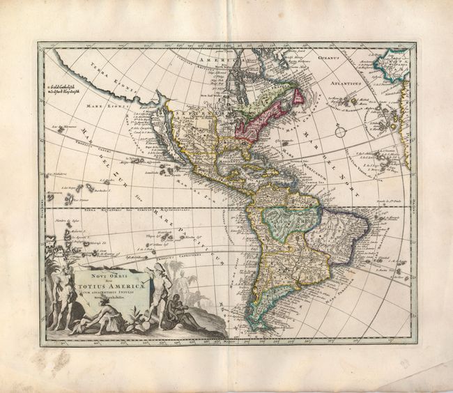
This is a fine map of the Americas featuring the mythical depiction of California as an island. Across the narrow strait, Fretum Aniani, is the kingdom of Anian and the large stretch of coastline noted as Terra Esonis. North America includes many interesting misplaced place names and cartographic errors: Louisiene and Apaches de Novajo appear to the northwest of the Great Lakes; two rivers flow past Santa Fe - one (R. del Norto) empties into the Gulf of California and the other (Magdalene Fl) flows in the approximate path of the Rio Grande and empties into the Gulf of Mexico; the Mississippi River delta is too far west; and a large lake appears in Carolina. The cartography in South America is more up-to-date with quite a bit of information derived from the Jesuits. Embellishing the southwest corner of the map is a highly pictorial cartouche featuring Indians, a pipe-smoking European, and several slaves. A color key in the upper left distinguishes locations within the map as Gold-Catholisch and Erdfarb Heydnisch [Gold = Catholic and Earth-brown = Heathen]. This refers to small dots of color used throughout the map.
References: McLaughlin #204; Tooley (Amer) p. 132 #90.
Condition: A
Nice impression and original color including gold leaf for the Catholic locations within the map. There is some soil in the margins, some just encroaching into the map border.