Subject: Western United States
Period: 1852-73 (dated)
Publication:
Color:
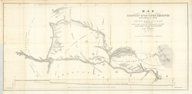
1) Map of the Country Upon Upper Red River (34 x 16") is from Capt. R.B. Marcy's report, Exploration of the Red River of Louisiana in the Year 1852. It covers an area in Texas wholly unexplored previously, including southwest Oklahoma (here Choctaw and Chickasaw Territory). At the time, the only information on the region was from Indians and Indian traders. The map details Captain Randolph Barnes Marcy's route of exploration through this part of Texas with camp dates, the route of the train from Preston to Warren's T.H. at Cold Spring, Indian villages and settlements, topography and hydrology. Filled with fascinating notations about the land and resources including a large profile of the entire region. Earlier attempts at exploration had been thwarted by the Spanish; Capt. Sparks in 1806, Lt. Pike again in 1806 and Col. Long in 1819-20. Marcy's instructions from Major Gen. Scott were to make an examination of the Red River and the country bordering it. Accordingly, Marcy started his adventure on May 16, 1852 from the vicinity of Ft. Arbuckle and reached the source of the upper branch of the Red River on June 16th. He then took a side trip of about 25 miles north to the Canadian River, reversed course and journeyed south, arriving at the main branch of the Red River on June 27th. After exploring the main branch to its source, he returned to Fort Arbuckle on June 28th. The explorers were greeted with great surprise as a report had spread about their massacre at the hands of the Comanche. Uncolored, folded, as issued with a 3" repaired tear from the binding trim to the word Estacado in a mostly blank area. (B+)
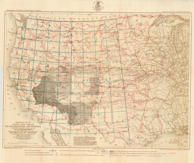
2) Progress Map of Lines and Areas of Explorations and Surveys (22 x 16.3") is a historically important map from Wheeler's amazing surveying efforts. Lieutenant George Wheeler in 1871 proposed a plan for mapping the United States west of the 100th meridian on a consistent scale of eight miles per inch. This map reports on the surveys from the seasons of 1869, 1871, 1872 and 1873. It gives the locations of occupied and abandoned posts, signal service stations, telegraphic lines, routes of cattle drives and trains and more. Printed color, folded as issued. Fine. (A+)
References: 1) Wagner-Camp #226:3
Condition:
See individual descriptions.