Subject: Western United States
Period: 1852-55 (dated)
Publication:
Color: Hand Color
Size:
22 x 24.8 inches
55.9 x 63 cm
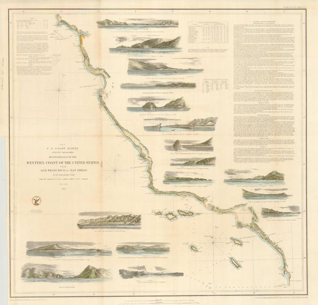
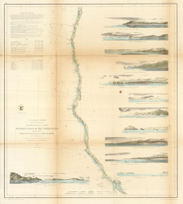
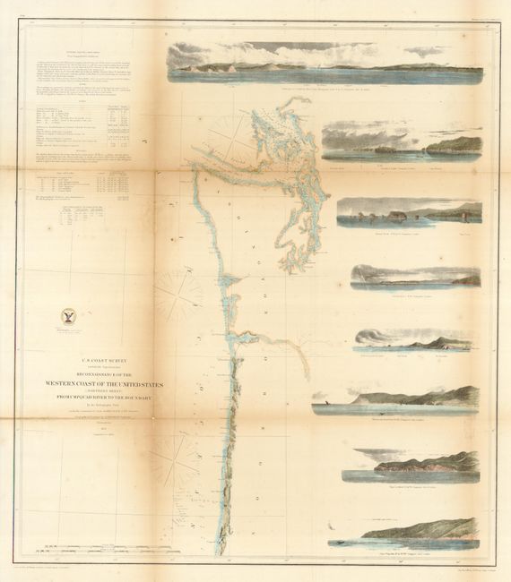
This is a great complete set of the three larger coastal survey maps that cover from San Diego to the border with Canada. They should not be confused with the slightly smaller, simpler charts that do not feature the large number of coastal views. Each is from the first official scientific reconnaissance of the Pacific coast and each outlines the coastal littoral, shows dangerous reefs and shoals, gives offshore bathymetric soundings, plus general and specific harbor and sailing instructions. Each measure approximately as given.
1) The fist chart (No. 9) covers the region from the Mexican boundary to Point Reyes. The most impressive feature is the 17 views of entrances and promontories along this rugged coastline, among them Santa Barbara, Catalina Harbor, and the entrance to San Francisco Bay. One of the most desirable Coast Survey charts. Dated 1852.
2) The second, produced two years later in 1854, details the California and Oregon coast from San Francisco Bay to the mouth of the Umpquah River in the north. Major points included are Bodega Bay, Shelter Cover and Trinidad Bay in California, and the Klamath River, Crescent City, Port Orford, Cape Blanco and the Rogue's River in Oregon. With 11 view including Cape Mendocino and the Crescent City Light House.
3) The last chart continues up the northern Oregon coast from the Umpquah River to the Straits of Juan de Fuca to include the full extent of Puget Sound. Names Cape Foulweather, Cape Lookout, Tillamook Head and False Tillamook, Cape Disappointment and Astoria at the mouth of the Columbia River, and Gray's Harbor. The seven large views include Cape Lookout, Destruction [Bay], and at the top the large "Entrance to the Columbia River, Cape Disappointment." This is the final map in the series, dated 1855. We've not previously offered these three charts together.
References: Heckrotte & Sweetkind #33; Schwartz & Ehrenberg, plt. #174.
Condition: B+
Each with full margins and good impression. All have been professionally conserved and deacidified with backing and expertly applied hand color. The occasional fold toning and tiny loss at fold intersections are well supported with backing.