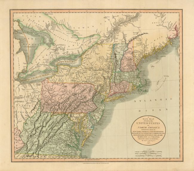
Subject: Eastern United States
Period: 1806 (dated)
Publication: New Universal Atlas
Color: Hand Color
Size:
20.5 x 18 inches
52.1 x 45.7 cm
This is a fine, early 19th century map of the states from Virginia to the District of Main. It extends to include lakes Erie and Huron with the region west of Pennsylvania labeled The Western Territory. The Connecticut Reserve is noted in present-day northeastern Ohio. The Connecticut Western Reserve, formally ceded to Connecticut after the Yankee-Pennamite Wars, was the last remnant of Connecticut’s old colonial sea-to-sea grant of all territory falling between the 41st and 42nd parallels. An area in present-day West Virginia is marked as Indiana. This region was originally granted to a Philadelphia trading company by the Iroquois Confederacy in 1768. Then in 1776 it was sold to the Indiana Land Company, but was also claimed by the State of Virginia as a part of her original charter. The resulting battle between the private land company and the state of Virginia was among the conflicts that eventually resulted in the Eleventh Amendment to the U.S. Constitution and is one of the most interesting chapters in the history of the young United States. The map contains a good amount of detail including topography, cities, towns, forts, Indian villages, roads, trails, rivers, springs, swamps, fishing banks, etc. There are also numerous interesting notations throughout the map.
References:
Condition: A+
Crisp impression and lovely original color.