Subject: Canada & United States
Period: 1792 (circa)
Publication: Morse's Geography
Color: Black & White
Size:
15 x 11.8 inches
38.1 x 30 cm
By the time of the Revolutionary War, the practice of awarding bounty land as an inducement for enlisting in the military had been a long-standing practice in colonial North America. Besides imperial bounty land grants, both colonial and municipal governments routinely compensated participants in and victims of military conflicts with land. Land was a commodity in generous supply, and governments seized upon its availability for accomplishing their goals.
Following this tradition, the Revolutionary governments used bounty land grants in their struggle for independence from Great Britain. They generally offered free lands in exchange for military service, provided they were victorious in their struggle. Thus, bounty lands were an effective technique for enrolling support for the war and encouraging re-enlistments. Generally the bounty lands were located on the western frontier, which provided another benefit to the government. Populating the frontier with citizens skilled in defense offered the best prospect in enticing other settlers to join them, thus eventually increasing the tax rolls.
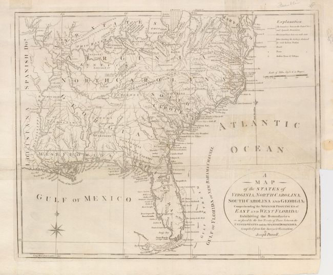
Lot of two maps from Morse's Geography, both approximately the size given. The first is by Joseph Purchell. It is an uncommon map of the early Southeast that shows a well defined New State of Franklin, within the borders of North Carolina. In 1785, settlers in present-day western North Carolina and eastern Tennessee organized a state government to be named in honor of Benjamin Franklin. Congress turned down their appeal but the state maintained a legislature and governor until 1788. This ephemeral state appeared on a small number of maps into the early part of the 19th century. The map shows early settlements, including a Moravian Settlement in North Carolina, and the Cumberland Settlements in present-day Tennessee. The map also notes native tribes and various Bounty Land Grants lands along the upper Mississippi River. Engraved by Taylor, published by John Jones. References listed are for this map.
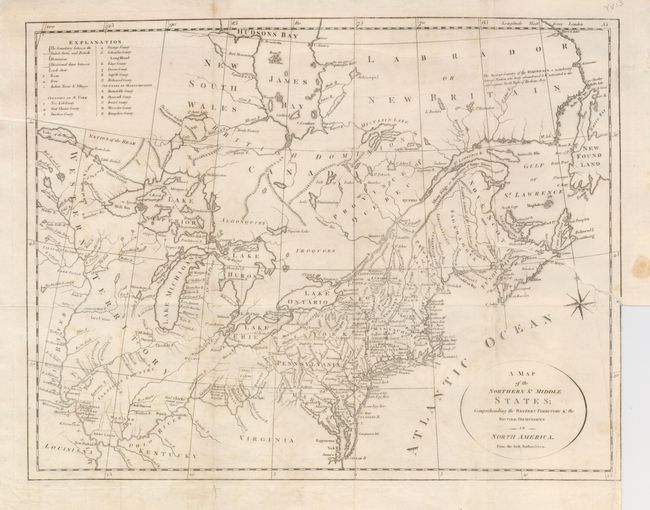
The second map extends from the area of Maine (Province of Main) and south to Virginia with fine detail. The map extends west to the Great Lakes and the confluence of the Ohio and Mississippi Rivers, and north to eastern Canada up to James Bay. There are several Bounty Land Grants including Genl Clarks, Donation Lands from the Commonwealth of Virginia, and Ohio Company in Ohio, and Wabash Company, New Jersey Company, and Illinois Company in Illinois. The Nation of the Bear is east of the Lake of the Woods. The geography is virtually identical to Amos Doolittle's map (McCorkle # 789.6) of the same title. The imprint for Morse's Geography is not present in the lower margin. Ref: McCorkle # 792.1; Kershaw #388.
References: Howes #M840; Sellers & Van Ee #1410; Baynton-Williams (TMC) 72, #5 p. 16.
Condition: C
Full margins. Issued folded, now flat with archival tape on horizontal fold to support weakness along fold. A long tear from binding trim just reaches into the map near Savannah. The second map is in better condition with a long binding trim tear but not other tape on verso (B).