Subject: Danube River
Period: 1693 (circa)
Publication: Atlas Nouveau
Color: Hand Color
Size:
47 x 22 inches
119.4 x 55.9 cm
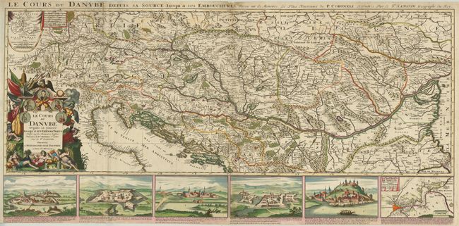
The course of the Danube River, from its source to the Black Sea, is charted on this superb, large-scale map. The map is based on Coronelli's great map published by Nolin in 1688. An inset in the upper left corner shows the source of the Danube in the Principality of Furstemberg. This region was the main theater of the confrontation between Christian Europe and the Ottoman Empire in the 17th century, and the map serves as an illustration of that continued struggle. The baroque title cartouche features medallion portraits of several rulers involved in the effort to push the Turks out of the region: Pope Innocent, John Sobieski of Poland, Leopold I of the Holy Roman Empire, King Joseph of Hungary, and Maximilian Emanuel of Bavaria. The allegorical design also incorporates a monk subduing a figure with a Koran, and on the other side a Christian soldier slaying a Turkish soldier. In contrast to these violent scenes, the tributary river gods of the Drava and Sava pour their waters into the flow of the Danube at the base of the cartouche. Along the bottom of the map are five prospects of fortress towns that were occupied by the Turks, along with a chart of the Bosphorus and Constantinople. On two joined sheets, as issued.
References:
Condition: B
Superb original color with gold highlights in the cartouche. There is some soil in margins, a few edge tears and some old paper repairs along the joint and on an old fold.