Subject: Nevada
Period: 1907 (dated)
Publication:
Color: Hand Color
Size:
32 x 20.5 inches
81.3 x 52.1 cm
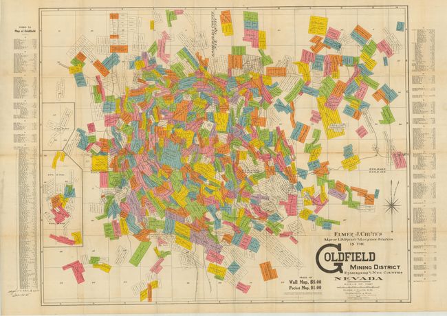
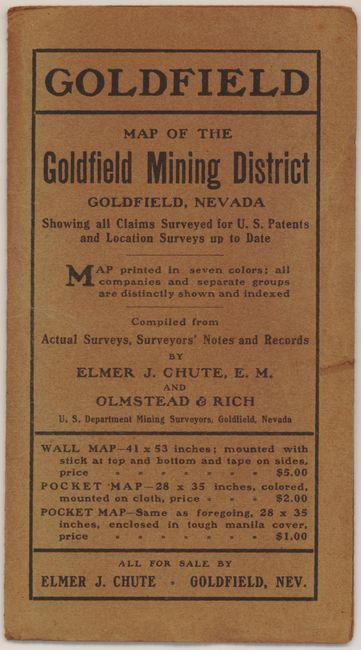
This is a very detailed and scarce, if not rare, pocket map detailing the vast mining claims in the Goldfield Mining District. It was published by Elmer Chute and Olmstead Rich of Goldfield, Nevada. The map details hundreds of claims in a colorful mosaic that resembles a patchwork quilt pattern. Railroads, roads and the city street layout of Goldfield are mixed into a densely detailed map. On the sides is an extensive alphabetical index locating the hundreds of mining claims by the owner's name. Large compass rose indicates magnetic variation. Blank verso. Next to the map's title is advertising text promoting this map for $1.00 and the wall map version (larger) for $5.00. The original brown paper covers (4 x 7.5") carry the title "Map of the Goldfield Mining District" and that the map is "printed in seven colors; all companies and separate groups are distinctly shown and indexed. Compiled from Actual Surveys, Surveyors' Notes and Records." The cover also notes three versions of this map available for sale. On the back cover is the blue stamp of "Fitchett's Stationary and Cigar Store 334 Main St. Goldfield, NEV". This is the ultimate collectable map of this famous mining town whose population reached 30,000 in 1906, making it the most populous city in Nevada at the time.
References:
Condition: B+
Map has fine color and is quite sound with just some closed fold separations and a little toning on some folds. The map is separated from covers. Covers are near fine.