Subject: United States - Central and Southwest
Period: 1856 (published)
Publication: New Universal Atlas
Color: Hand Color
Size:
13 x 16 inches
33 x 40.6 cm
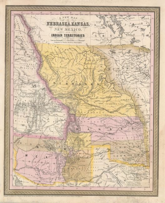
When Desilver took over the publication of Mitchell's atlas in late 1855, he realized that the atlas was missing a map showing the new territories of Kansas and Nebraska. There was considerable public interest in these territories that had been created by the Kansas-Nebraska Act of 1854 due to the politics involved. The act repealed the Missouri Compromise of 1820, and allowed settlers in those territories to determine if they would allow slavery within their boundaries. Nebraska Territory stretches between Kansas and the border with Canada, and from the continental divide to the early Minnesota Territory at the Missouri River. Kansas stretches west to include South Park in present-day Colorado. New Mexico Territory is shown in its largest configuration, including present-day Arizona and much of southern Colorado. Oklahoma has its correct boundaries but is Indian Territory. Interesting features and notations include several emigrant and exploration routes in the region, the Great Indian Treaty Ground in Nebraska, and an Uninhabited Region in Arizona. The Road from Ft. Smith to Santa Fe 900 miles made by order of Gen. Arbuckle" and another Road from Ft. Smith to Dona Ana 820 miles made by order of Gen. Arbuckle refer to routes to the gold mines in California. Another unique feature of this map is one that appears to be a coloring error; the region west of Nebraska shows Washington Territory extending into Canada reflecting U.S. claims to the region that had been resolved in 1846. Desilver's Philadelphia imprint is below the title, and the old copyright date of 1850 appears below the neatline. This map is rare because it appeared only in some of the 1856 editions and was replaced sometime in 1857 with a revised edition that has a more pronounced bulge in the western boundary of Nebraska Territory and is enclosed in the new scroll border.
References:
Condition: B+
Very nice impression with original hand coloring that is slightly faded. There are some light mildew spots in a portion of the upper and lower margin. The left, binding side, was trimmed but has been extended professionally and in a manner that makes it looks contemporary to the map's production.