Subject: Eastern United States
Period: 1805 (dated)
Publication:
Color: Hand Color
Size:
18.5 x 13.3 inches
47 x 33.8 cm
By the time of the Revolutionary War, the practice of awarding bounty land as an inducement for enlisting in the military had been a long-standing practice in colonial North America. Besides imperial bounty land grants, both colonial and municipal governments routinely compensated participants in and victims of military conflicts with land. Land was a commodity in generous supply, and governments seized upon its availability for accomplishing their goals.
Following this tradition, the Revolutionary governments used bounty land grants in their struggle for independence from Great Britain. They generally offered free lands in exchange for military service, provided they were victorious in their struggle. Thus, bounty lands were an effective technique for enrolling support for the war and encouraging re-enlistments. Generally the bounty lands were located on the western frontier, which provided another benefit to the government. Populating the frontier with citizens skilled in defense offered the best prospect in enticing other settlers to join them, thus eventually increasing the tax rolls.
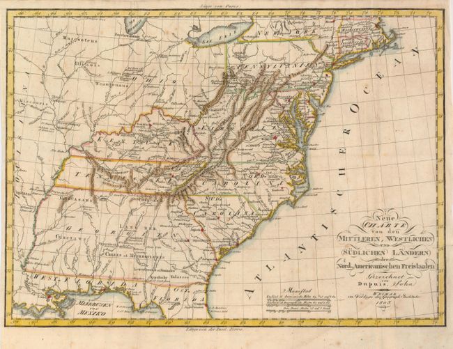
This scarce map of the young United States was issued by the Weimar Geographisches Institut. It covers from Massachusetts through northern Florida and inland to the Mississippi River valley. The map provides a good view of the early settlement that was beginning to flourish on the western frontier. Near the confluence of the Mississippi and Missouri Rivers are lands belonging to the Illinois Company and New Jersey Company, two of the westernmost Revolutionary War bounty land grants. Several roads are shown connecting the frontier with the more settled region on the eastern seaboard. Georgia Territory extends to the Mississippi River and Indian tribes and villages occupy most of the territory that would eventually become Alabama and Mississippi. The Ohio valley is also shown to be Indian territory except for a few prominent forts.
References:
Condition: B+
Issued folded. Original color with faint scattered foxing. There is a nearly invisible, expertly repaired binding tear at left.